MISCELLANEOUS PUBLISHERS
Top of Page Href
Miscellaneous Cycling Map Publishers
The following publishers are represented here:
Automobile Association (AA) and Royal Automobile Club (RAC) - Click hereDunlop - Click hereHovis - Click hereCharles Smith and Son - Click hereW. H. Smith and Son - Click hereEdward Stanford - Click hereJ. & C. Walker - Click hereJohn Walker & Co. - Click hereJames Wyld - Click here
Href1
AA (Automobile Association) and RAC (Royal Automobile Club)

Href2
Dunlop
A first series of Dunlop maps was produced in the 1920s, based on W. & A. K. Johnston mapping from 1889. As might be expected, these were completely out of date. The Dunlop ‘On The Road’ booklets (1920s), were low-detail strip maps produced by Burrows of Cheltenham. Later, Burrows were to publish a Dunlop-branded Motorists Atlas of the British Isles, utilising Bartholomew's 16m to an inch mapping. This also included an extract of Bartholomew's 3m to an inch map of the Lake District, and an extract of Snowdonia on the half-inch scale.Href3
Hovis

%20map%20W%20Yorks.jpg)
In 1920 Hovis published a book Where to go and how to get there. This included a series of maps: England, Wales & Isle of Man on 28 large pages (numbered north-south). Scotland was covered on two pages at a smaller scale . The mapping was by Bacon at 8m to an inch. This was periodically reissued.
A 1925 and onwards road atlas – Touring Maps of England, Wales and Scotland - published by Hovis utilised standard small-scale Bartholomew maps and was aimed primarily at motorists.
Href4
Charles Smith & Son
- The Ordnance Map of England & Wales, reduced to ¾ inch to a mile [whose?]
- England & Wales in 65 sheets, 2m to an inch, price 1/6d coloured [Cruchley/ Gall & Inglis]
- England & Wales in 16 sheets, 4m to an inch, price 2/6d on cloth in case [Black/Bartholomew]
- England & Wales in 60 sheets, 4m to an inch, price 1/- on cloth in case [Pocket Series derivatives of Black/Bartholomew base mapping]
- England maps, various prices
- County maps 6d and 1/-
- 20 miles round London, ¾ inch to a mile
- 20 miles round London, 4m to an inch
- 25 miles round London, 2m to an inch
- 50 miles round London, 4m to an inch, roads coloured with dangerous and difficult places marked.
In the 1899 Cyclists’ & Motorists’ Road Book they were advertising ‘Cheap Maps’ of the following:
- The Ordnance Map of England & Wales, ¾ inch to a mile, 1s paper, 2s cloth, 2/6 coloured
- England & Wales in 60 sheets, 2m to an inch, with roads coloured, mounted on cloth and folded for pocket, 1/6. [Cruchley/ Gall & Inglis]
- Bartholomew’s New Half-inch Map of England & Wales, in 37 sheets. Coloured to show heights, mounted to fold for pocket 2/6. [Either the advert is later than thought, or not all sheets were yet published. Price higher than Bart’s own]
- Cycling Road Map of England. 5 miles to an inch, main roads specially coloured. In 7 sheets. Price on cloth, in case, 1/6. [Presumably Bacon]
- County Maps for Cyclists. With main roads coloured and other information specially prepared. Mounted on cloth to fold for pocket 1/-. [Presumably Bacon, or possibly Philip]
- Environs of London. 1 inch to a mile, in 4 sheets, mounted on cloth to fold, 3/6.
- Twenty Five Miles Round London, new edition, thoroughly revised and corrected, 2 miles to an inch. Price, with roads coloured, 2/6, mounted on cloth to fold in case, 3/6.
- Cyclists’ Map of the Environs of London extending from Ware, Tring etc on the North, to East Grinstead, Tunbridge Wells on the South; and from Henley on the West to Chelmsford, Chatham and Maidstone on the East. New edition, thoroughly corrected, ruled in Five Mile Circles, with best Cycling Roads coloured. Scale 2 miles to an inch. Folded in cover, 1s 6d, or printed on cloth, in neat pocket case, 2s 6d.
- Fifty Miles Round London. Ruled in 5 mile circles, with Main Roads coloured. Mounted on cloth to fold in case 3s 6d.
- The Roads of England and Wales. Giving a description of the Contour and Surface, with Mileages of the Main Roads and Principal Cross Roads. Notes of the Chief Cities and Towns, and References to Antiquities and Curiosities, 5s.
- Contour Road Books – North England and SE England now ready, SW England ‘in preparation’ – evidently Gall & Inglis; SW England appeared in 1900.
- Sixty Miles N of London, Sixty Miles West of London, Sixty Miles South of London – Scale 2m to an inch, Main Roads coloured. Mounted on cloth, to fold for the pocket, 2s.
- Cycling Maps of Ireland (no further details given)
Href5
W. H. Smith & Son

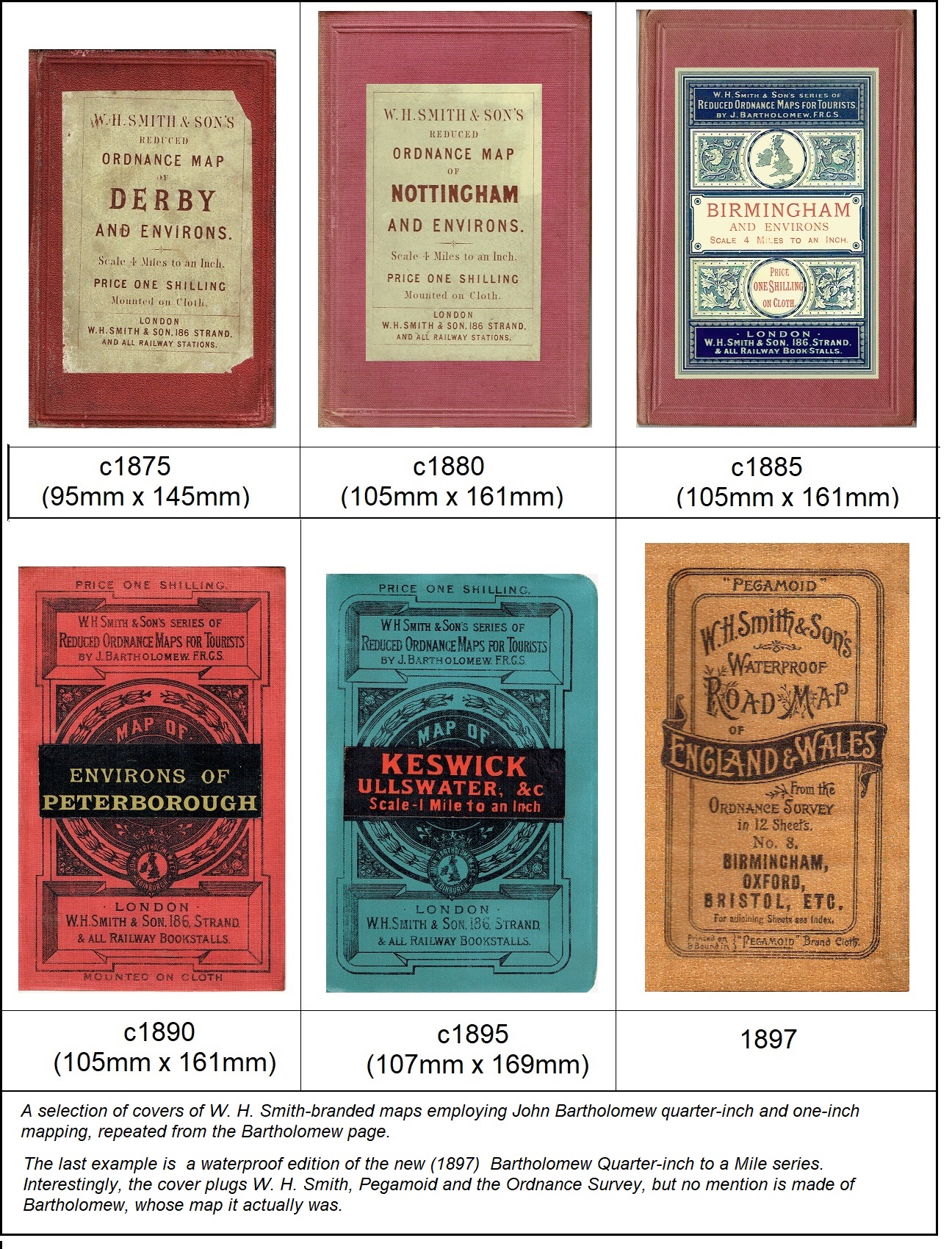
The index basically covered four types of plan –
· The initial
quarter-inch coverage based on the 1866 England & Wales mapping for A.
& C. Black, reproduced by lithography as locally-centred sheets. Named by county,
or town name & environs.
· Town plans – a
very small subsection of the town plans (British and foreign) published by
Bartholomew
· ‘Hybrid‘ – combination
of a town plan and an environs map, introduced in the 1890s.
· Other one-off plans, mostly on the one-inch or half-inch scale
Index numbers are given where maps appeared in the 1874-onward (‘early’) and 1891-onward numberings, though these never appeared on the maps or covers themselves. During their publication period the maps would have been revised and, in the case of town plans, completely redrawn. Maps which underwent a change of name (e.g. Central Wales to Wales – Central) I have treated as one map; maps published simultaneously under different names have been treated as two (e.g. Carmarthen & South-West Wales and Wales – South-West). I have not noted the numerous instances where what might be ‘Environs of Barchester’ on the cover would be ‘Barchester & Environs’ on the map itself. In some cases index numbers were reused. Note that the same title might apply to more than one map.
Aldershot & Environs, ¼”
Published 1871, last listed 1904. Numbered 1 in1874 index, also 1 in 1891 index
Aldershot Camp & Environs, ½”
Published 1880 or 1881, last listed 1899 (2 under 1891 index)
Barrow & Ulverston (1”)
Appeared in 1891 John Walker edition of index and c.1893 W. H. Smith index, as 3, but number left vacant thereafter. Seems to have been same map as 89 Ulverston & Furness (q.v.)
Around 1882-90 Barrow was shown on the index map as a map centre, but no map of that name ever appeared, other than this.
Bath, Plan & Environs
Combined town plan and ¼” environs map. Short-lived (1893 – 1896?) as 105 in index.
Bedford, Hertford, ½”
First included in the 1897 preliminary half-inch series of 12 maps; to become one of the England & Wales series.
Bedford & Environs, ¼”
Later Bedfordshire. Advertised 1871 – 1903. Numbered 2 in early index, 4 under 1891 index.
Belfast & NE Counties, ¼”
First included under District Maps 1900; in 1904 renumbered in new Irish ¼" Series.
Birmingham District , ½”
Published and advertised 1897 under New Reduced Ordnance Survey of England & Wales heading; to become one of the England & Wales series.
Birmingham & Environs, ¼”
Advertised 1871 – 1896. Numbered 3 in early index numbering, 5 under 1891 numbering.
Birmingham, Plan
Published by 1874, numerous editions followed. Numbered 53 in early index numbering, 6 under 1891 numbering. Still on sale 1914.
Blackpool, Plan with Environs
Combined town plan and ¼” environs map. Advertised 1891 – 1899, index number 106. Included under town plans in final years.
Bournemouth, Plan with Environs
Combined town plan and half-inch environs map. Advertised 1893 – 1904, index number 107. Also included a short guide.
Brighton & Sussex Coast, ¼”
Advertised 1871 – 1895, numbered 5 in early index numbering, 7 under 1891 numbering.
Brighton & Sussex Coast, ½”
First listed 1891, Index number 8, Contour-coloured edition published 1896. 1897 transferred to preliminary half-inch series of 12 maps; to become one of the England & Wales series.
Brighton, Plan
Originally Brighton, Town & Suburbs, later with Index. Various editions 1880 to 1904. 1891 index number 9.
Bristol & Environs, ¼”
Advertised 1871 (or earlier) – 1892; number left vacant after withdrawal, then briefly reused for Bristol, Plan with Environs combined town plan and district map c1894. Index number 4 under early numbering, 10 from 1891.
British Isles, General Railway Map
Advertised 1873 onwards; early index number 49 (50 on linen), numbered 11 from 1891. Probably same as later 104 – General Railway Map.
British Isles wall map
Advertised 1891 – 1895, map probably on sale longer, but not included in these indexes as atypical. Numbered 58 in early index, 12 from 1891.
Buxton, Plan of & Neighbourhood.
Published 1885, 6” = 1m.
1889 listed both under ‘Specials’ and under town plans; renamed Buxton Plan & Environs 1890 under Town Plans only. Number 13 in 1891 index. Dropped from index after 1898 but a Buxton Town Plan also appears in 1933 index.
Buxton was named on the key plan accompanying the sheet indexes to the Pocket Series, but no quarter-inch map ever appeared under the Buxton title.
Buxton, Matlock, Dovedale etc ½”
Advertised 1885 – 1902; index number 14 from 1891; same map as 67 Matlock, Buxton, Dovedale etc.
Cambridge & Environs, ¼”
Huntingdon & Cambridge on map. Also appeared in index as Cambridgeshire. Advertised 1871 (or earlier) , withdrawn 1906. Early index number 7, 1891 number 15.
Cardiff & Environs, ¼”
Advertised 1891 – 1902. Index number 108.
Carlisle & Environs, ¼”
Advertised 1871 (or earlier) – 1894. Early index number 8, 1891 number 16. Superseded by 21 Cumberland & Westmorland from 1896, 16 in index used for Connemara.
Carmarthen & SW Wales, ¼”
Published in or by 1871, early index number 6, from 1891 number 17. Same map as later Wales – South-West, this number and title dropped 1891 or 1892.
Channel Islands (on various scales)
Briefly listed as 110 c.1894 then dropped from indexes, though map still published c. 1950
Cheltenham, Plan with Environs
Combined town plan and ¼” environs map. Advertised 1893 – 1903 as index number 109.
Cheshire, ¼”
Published 1871 (or earlier), withdrawn 1904. Early index number 10, 1891 18.
Central Wales, ¼”
see Wales – Central
Clyde Watering Places, ½”
Advertised 1891 – 1899 as index number 19. Presumably the same as Upper Clyde map published 1889 by Bartholomew.
Connemara District, ¼”
Published late 1897, included in some indexes as 16. in 1904 renumbered in new Irish ¼" Series.
Contour Touring Map of England & Wales for Cyclists, 13m = 1”
See Pocket Touring Map of England & Wales for Cyclists
Cork & Killarney, ¼”
See Killarney
Cornwall, ¼”
Advertised c.1880 – 1889 as index number 20. Also in 1878 Black’s Guide advert. Same map as Land’s End & Cornwall of 1871, advertised same time.
Cornwall, ½”
Published and advertised 1897 under New Reduced Ordnance Survey of England & Wales heading. Later included in the new national half-inch series for England & Wales.
Cumberland & Westmorland, ¼”
On the publication of a new 3m to an inch map of the Lake District in 1893, the former Lake District quarter-inch map was renamed Cumberland & Westmorland, as 21 in the index. Short-lived, probably using up old stock.
New edition published late 1895; Advertised 1896 – 1901, initially as index number 21. See also Lake District.
Cycling Maps (10m = 1”)
See Tourists’ & Cyclists’ Maps
Cyclists’ Pocket Map
See Pocket Map
Dartmoor & Environs of Plymouth, ¼”
Advertised 1890 – 1894; 1891 index number 21. Probably former Devon, South quarter-inch map of 1880 renamed to avoid confusion with new Devon, South (or South Devon) half-inch map. See also under Plymouth.
Derby & Environs, ¼”
Index title altered to Derbyshire, 1897. Published in or by 1871, withdrawn 1901. Early index number 11, 1891 number 22.
Devon, North, ¼”
Published by or in 1871. Numbered 12 in early index. Numbered 23 in 1891 index but briefly renumbered 24 shortly before abolition of numbering system. Expanded & altered to 23 Devonshire, (c. 1896), to avoid confusion with new half-inch map), at higher than standard price. Last listed 1905.
Devon, North, ½”
Published and advertised 1896 as number 26 in index. Contour coloured. Following year moved under New Reduced Ordnance Survey of England & Wales heading (as North Devon). Later included in the new national half-inch series for England & Wales (Sheet 35).
Some 1897 indexes have this as numbered 23 alongside 24 Devonshire, both as quarter-inch, though wrong in respect of Devon, North.
Devonshire, ¼”
Successor to Devon, North quarter-inch – see above
Devon, South & Dartmoor, ¼”
Listed 1880 – 1889. Probably renamed Dartmoor & Environs of Plymouth (q.v.) on publication of half-inch Devon, South map, 1890.
Devon, South, ½”
Initially (1890) listed as both Devon (South) among General Maps and as South Devon under Special Maps. Numbered 24 from 1891.
Three maps on the half-inch scale appeared in succession with this title. The first, c1890, was not a Barts map, though in a standard W. H. Smith/Bartholomew cover. This was titled South Devon & Dartmoor on cover. The map itself was titled W. H. Smith’s Reduced Ordnance Map of South Devon, with no other attribution. W. H. Smith had previously (1880) provided the map for sale by Cranston’s of Dartmouth and was probably sold generally in the 1880s before (mis)appearing in the Barts catalogue. The National Library of Scotland has an earlier version of its base map viewable at Cruchley's Map of Devonshire. The map dates back to c.1820 but, unlike the bulk of Cruchley’s products, was not of Cary origin.
The second (1892) map of this title was a true Barts map, using stippling - see under Bartholomew: Early Half-inch Maps preceding the National Series. Superseded 1896 by contour-coloured version, still Devon, South in index but South Devon on cover. In 1897 listed under New Reduced Ordnance Survey of England & Wales heading (as South Devon). Later included in the new Bartholomew national half-inch series for England & Wales (Sheet 36). Later titled Dartmoor.
Donegal County, ¼"
Published late 1897, briefly numbered 17 before numbering system dropped. Removed from District maps in 1904, as Donegal, and incorporated into in Irish ¼" Series
Dorsetshire, ¼"
Advertised 1871 – 1900, originally as Dorset. Numbered 13 in 1874 index numbering, 25 in 1891 numbering.
Dover & Watering Places of Kent, ¼”
This was the same map as Kent Watering Places, but appeared as number 14 in the index. It was dropped in 1872 with the number left vacant. Title reappeared as Dover & Kent Watering Places, index number 26 in 1891, alongside 46 Kent Watering Places, but last listed 1893.
Dublin, Plan with Environs
Advertised 1891 – 1907, index number 27. In 1897 given as with Index & Guide. Formed basis of 1904 Irish ¼" Series sheet Dublin & Athlone.
Durham, Plan with Environs
Combined town plan and ¼” environs map. Advertised 1891 – 1907, index number 28. Later listed under town plans.
Eastbourne, Plan of Town
Published and advertised 1879, 1891 index number 29. Later adverts state as including Index & Guide. Successively reprinted to 1933 or later.
Edinburgh, Plan with Index
First appeared in index for 1894 (as number 30), though map of earlier origin and remained in print until 1933 or later.
Edinburgh, Environs of, ½"
Appeared in index c.1894 as number 31, but in 1895 replaced by 1½" to mile map using same index number.
Edinburgh, 1½" to mile
Barts published this contour-coloured map in 1892, but not included in index until 1895, replacing a half-inch map as number 31. Last listed here 1899.
Edinburgh, Pocket Guide with Maps
Advertised here 1894 – 1903, as index number 112.
England & Wales – see under ‘Tourist’ maps
Essex County, ¼”
Advertised 1878 – 1902, 1891 index number 32
Exeter & Environs, ¼”
Published and advertised by 1871, withdrawn 1895. Early index numbering 15, 1891 numbering 33.
General Railway Map of British Isles
First listed 1873 as index number 49, 1891 numbering as 11 (12 for roller-mounted version, advertised c1874 - 1890). Also advertised c.1892 onwards as index number 104 (briefly 103), alongside number 11, Same price, same title.
General Railway Map of Great Britain
Advertised here 1874 – 1876 as number 52, thereafter number used for Tourist’s Map of Scotland
Geological Map of England & Wales
Advertised here 1898 onwards.
Geological Map of Ireland
Advertised here 1898 onwards.
Geological Map of Scotland
Published 1892, advertised here 1895 onwards, originally as variant of index number 102, Scotland.
Glasgow, Plan with Index
Advertised here 1894 onwards, index number 34.
Glasgow, Environs, ½"
Advertised here from1894 as index number 35, still advertised 1910.
Gloucestershire, ¼”
Published and advertised by or in 1871, originally Gloucester & Environs. Early numbering 16, 1891 numbering 36. C.1880 sold as Gloucester & Environs (index), Gloucestershire (on map), Gloucester, Cheltenham & Environs (cover). Withdrawn 1901.
Grange, Carnforth etc, 1”
Listed from 1880, withdrawn by 1891 (never received index number). Area later incorporated into Windermere & Morecambe Bay map.
Great Britain, Railway Map of – see General Railway Map, early index number 52.
Hampshire, ¼”
Advertised c1882 to 1907. Numbered 37 in 1891 index. Large overlap with Salisbury & Isle of Wight, and Isle of Wight maps.
Harrogate, Plan with Environs
Combined town plan and ¼” environs map. Advertised 1894 – 1907, later listed under town plans. Numbered 39 in index.
Hastings & St Leonards, Plan
Advertised here 1880 – 1908, 38 in 1891 numbering. Later included guide.
Hereford & Environs, ¼”
Published and advertised in or by 1871. Early index number 17, 1891 index number 40 (41 in John Walker index). Later Herefordshire etc (1899 Hereford & Worcester, but withdrawn that year).
Hertfordshire & District, ¼”
Advertised 1880 – 1901; numbered 41 from 1891 (40 in John Walker index). Hertford & Environs in earliest indexes.
Hull, Plan with Environs
Advertised from 1891 as index number 42. Combined town plan and ¼” environs map. Replaced 1897 (retaining number) by Hull, Plan of, with Index & Guide, last listed 1911.
Huntingdon & Cambridge, ¼”
See Cambridge
Huntingdon & Cambridge, ½”
Advertised from 1898, under New Reduced Ordnance Survey of England & Wales heading. Later included in the new national half-inch series for England & Wales.
Ipswich & Environs, ¼”
Published and advertised by or in 1871 as number 18. Last advertised 1894, as 1891 index number 43. Number subsequently left vacant.
Ireland, Touring Map
See Touring & Cycling Maps, Sheet 103
Isle of Man, ½”
Advertised from 1893 or 1894 as index number 111. Last appeared 1899.
Isle of Wight, 1”
Advertised here from 1880, later with Guide. 1891 index number 44. A 1908 reissue had contour-colouring and inset town plans. Still advertised in ‘Pocket Series 1914.
Isle of Wight, ¼”
Advertised here from 1876, early index number 57. Later Isle of Wight and parts of Hampshire. Largely duplicated by Salisbury & Isle of Wight and Hampshire maps and dropped c.1882.
Isle of Wight, ½”
Advertised here by or in 1889. Originally described as 4m to an inch on cover. 45 in 1891 numbering. Withdrawn 1897 on publication of New Forest half-inch map (q.v.).
Kent Watering Places, ½”
Published 1891 as number 46 in index. Not to be confused with quarter-inch map following. Later Kent and included in the new national half-inch series for England & Wales, 1897.
Kent, ¼”
Advertised by or from 1871 to 1912. Early index number 19, 1891 index number 47. Originally Kent Watering Places, but Environs of Dover & Watering Places of Kent on map itself and also listed under that name (see Dover)
Keswick, Buttermere, Ullswater etc, 1”
Also Keswick, Grasmere etc (and other combinations) on cover and map. 48 in 1891 index numbering. Advertised from 1880, variously republished (e.g. 1893) until c.1914.
Killarney, ¼”
Advertised as 112 in index c.1894 as Killarney Lake District. Renumbered 50 in 1896. 1897 retitled (and probably enlarged) as Killarney & Cork, also sold as Cork & Killarney. Removed from District maps in 1904 on its inclusion in new ¼" Irish Series.
Lake District, ¼”
Published and advertised by or in 1871. Variously named:
1871 Lake District of Westmoreland [sic] & Cumberland, also listed as Windermere & Lake District
1874 just Lake District
1878 Lake District of Westmoreland & Cumberland
1885 just Lake District again
1889 Lake District & Windermere,
21 in early index numbering, 49 in 1891 series. Withdrawn and replaced by 3m=1” Lake District map from 1893 (see following), which took over its 1891 index number.
Quarter-inch coverage of Lake District restored as 21 Cumberland & Westmorland (q.v.) 1896.
Lake District & Windermere, 3m = 1”
Originally appeared in Baddeley’s Thorough Guide to the Lake District, 1880, as general map. Advertised here from 1893 as index number 49 and superseding Lake District/Cumberland & Westmorland quarter-inch map.
Still in 1935 Barts catalogue, but gradually superseded by new ¼” mapping.
Lake District, 1”
A one-inch map of this title was added in 1891 as 50 in index numbering. Various more local maps of parts of the Lake District had been listed since 1880 and continued on sale alongside for some years. The Lake District one-inch was dropped c.1894.
A new, larger Lake District map on this scale was published 1913. This eventually became Bartholomew's Walkers' Map of the Lake District in the Harpers Collins era.
Lancashire, ¼”
Advertised 1877 or 1878 - 1905. Index number 51 in 1891 listing.
Land’s End & Cornwall, ¼”
Published and advertised by or in 1871, number 20 in early index numbering. Last listed 1890. See also Cornwall, which was advertised simultaneously and presumably the same map.
Leamington and Warwick Environs, ¼”
Advertised from 1886 (initially Leamington on cover), number 52 in index, but withdrawn in 1895. From 1894 briefly listed alongside new 126 Warwickshire, with plans.
Leeds & Environs, ¼”
Published and advertised by or in 1871, 25 in early index numbering. Withdrawn 1890, replaced by Leeds, Plan & Environs in 1892, 55 in new index numbering.
Leeds, Plan with Environs ¼”
Combined town plan and ¼” environs map. Advertised 1892 – 1898, as number 55 in index. Replacement for Leeds & Environs map withdrawn in 1890.
Leicester & Environs, ¼”
Published and advertised by or in 1871, 22 in early index numbering. 1891 numbering 53, last listed 1898.
Lincoln & Environs, ¼”
From 1891 listed as Lincolnshire & Environs.
Published and advertised by or in 1871, 23 in early index numbering. For some reason dropped from indexes c.1881-85, though still named on adjoining index map of map centres. Probably the line containing Lincoln and York maps dropped accidentally. 1891 numbering 54, last listed 1904.
Liverpool & Environs, ¼”
Published and advertised by or in 1871, 24 in early index numbering. Numbered 56 in 1891 index numbering, last listed 1906.
Liverpool and its Surrounding Railways
Advertised here 1871 (or earlier) until 1873, but withdrawn before numbering system.
Liverpool, Plan
Listed from 1874 as index number 54, became 57 in 1891 numbering. From 1897 advertised as ‘with index’. Periodically revised to 1933 or later.
Llandudno & Environs, ½”
First listed c.1892, 120 in index numbering. Dropped by 1894, number 120 used for World Series map. With hill-hachuring. Formed basis of 1897 Wales, North/North Wales half-inch map ultimately included in national series.
Loch Lomond & Trossachs, ½”
First listed 1891, though used standard Barts mapping already appearing in its Scottish national series, which included a larger sheet of the same name. Numbered 58 in index. Last advertised 1899.
London & Environs, ¼”
Published and advertised by or in 1871, early index number 26. Numbered 59 in numbering from 1891; also J. C. Walker version from 1897.
1899 title subtended ’50 mile radius map’, also titled on map as ‘Cycling Map of 50 miles round London’. Superseded by new ¼” mapping from 1912.
London & Environs (1”)
Advertised from 1877; numbered 60 in early index numbering, also 61 mounted on linen. Coincidentally 60 in 1891 index, one of three maps under this title on different scales.
Contoured from 1908. Advertised in CTC Handbook 1932. Noted in 1935 Barts catalogue as shortly to be reissued in two sheets.
London & Environs, ½”
Published 1891 and appearing as 61 in index, one of three maps under this title on different scales. Withdrawn 1899, London area by then covered by national half-inch series.
London Railway Map
London and its Railways, ten miles round, advertised by 1871. From c. 1874 listed as Railway Station Map of London & Environs, 47 under early numbering scheme. By 1891 listed as 62 London & Environs Railway Station Map. Last appeared here 1902.
London, Plan
First listed here c.1874 as New Large Plan (later with Index & Guide). Early index numbering 45, also 46 on linen. Numbered 63 in 1891 index. Various mountings & prices, still appearing in 1933 index
London, The City (12" = one mile)
First listed here 1887, withdrawn 1907. 64 in 1891 index numbering.
London, Pictorial Bird’s Eye View
First listed here c.1893, withdrawn 1895, index number (113) re-used. Also appeared in ‘Pocket Guide & Atlas to London’.
London East, Plan
Although apparently published 1894, not listed here until c.1896, taking over index number 113. Withdrawn from index 1912, but from 1907 duplicated and eventually replaced by new London NE & SE sheets,
London South, Plan
Listed as 114 in index, first listed 1894. Later advertised as ‘with Guide’. Withdrawn from index 1912, but from 1907 duplicated and eventually replaced by London SE & SW sheets,
London North, Plan
Listed as 115 in index, first listed 1894 although apparently published 1892. Withdrawn 1907 replaced by new London NE & NW sheets.
London West, Plan
Listed as 116 in index, first listed 1894. Withdrawn 1907, replaced by new London NW & SW sheets.
Manchester & Environs, ¼”
Advertised by or from 1871, early index number 27. 65 in 1891 index. Last listed 1906.
Manchester and its Surrounding Railways
Generally advertised by or from 1871, though first listed here c.1873.
Manchester, Plan
Listed from 1874 as index number 55, became 66 in 1891 numbering. From 1897 advertised as ‘with index’. Also appears in 1933 index.
Matlock, Buxton, Dovedale, ½”
Advertised 1887 – 1902; index number 67 from 1891; identical map to 14 Buxton, Matlock, Dovedale etc.
Melrose & Abbotsford Pocket Guide.
Published 1892, though first to be listed here was the 1897 second edition. Never numbered. Various editions to 1950s. Facsimile edition published 2010.
This was an odd 'outlier' in the index, though it had some small map and plan extracts by Bartholomew. The inclusion in the Pocket Series of a guidebook, rather than a map, and of a Scottish rather than English district at that, can be attributed to the close acquaintance of John Bartholomew with the book’s author, Ralph Richardson, through their involvement with the Royal Scottish Geographical Society and elsewhere. Giving it a plug would help advertise it south of the Border.
Middlesex, ¼”
A Middlesex, County map was listed in W. H. Smith adverts included in A. & C. Black’s guidebooks in the late 1870s, but never appeared in the indexes included with the maps. Probably the same map as London & Environs, ¼” (q.v.). However, need not necessarily have been a Bartholomew map.
Naturalists’ Map of Scotland
See under Scotland
New Forest, ½”
Published and advertised 1897 under New Reduced Ordnance Survey of England & Wales heading; to become one of the England & Wales series.
Newcastle & Environs, ¼”
Publshed and listed by or from 1871, number 28 in early index. Numbered 68 in 1891, but very soon withdrawn, superseded by the following entry.
Newcastle, Plan with Environs
Combined town plan and ¼” environs map. Advertised 1892 – 1902 as number 68 in index, replacing Newcastle & Environs map withdrawn in 1891.
Newport, Monmouth etc, ¼”
Publshed and listed by or from 1871, number 30 in early index. Number 70 in 1891 index, last listed 1896.
Norfolk Broads Special Map (1”)
Only advertised c.1894, as number 117 in index.
Norfolk County, ¼”
First listed 1880. From 1891 named Norfolk, County and Environs of Norwich following demise of separate Norwich & Environs map. 71 under 1891 index numbering. Last listed 1904.
Northamptonshire, ¼”
First listed 1896, last listed 1903. Soon renamed Northampton & Huntingdon. Took over index number 76 (ex Plymouth).
Northumberland, ¼”
Publshed and listed by or from 1871, number 29 in early index. Number 69 in 1891 index, last listed 1907.
Northumberland, North, ½”
First listed 1897 under New Reduced Ordnance Survey of England & Wales heading. Later included in the new national half-inch series for England & Wales.
North Devon, ½”
See Devon, North
North Wales, ¼”
See Wales, North ¼”
North Wales, ½”
See Wales, North, ½”
Norwich & Environs, ¼”
Published and listed by or from 1871, number 32 in early index. Withdrawn by 1891, that year former Norfolk map 71 quoted as Norfolk, County and Environs of Norwich.
Nottingham & Environs, ¼”
Later Nottinghamshire . First listed 1874, 33 in early index numbering. Last listed 1899 as 72 in 1891 numbering.
Nottingham, Plan
First listed 1893, last listed 1902 as index number 110. Initially produced for British Association Annual Meeting, Nottingham, 1893.
Oban & Environs, ½”
First listed here 1894, but appeared elsewhere 1889. Last listed 1899, index number 73.
Oxford, Plan with Environs
Combined town plan and ¼” environs map. First listed 1895 as index number 74. Last listed here 1906.
Oxford & Environs/ Oxford, ¼”
Publshed and listed by or from 1871, 34 in early index numbering. At one period Oxford & Buckingham on both cover and map. Last listed 1901.
Under 1891 numbering scheme numbered 74 but 1895 changed to 105, previously used for Bath, Plan & Environs, and renamed Oxfordshire. Old number used for new Oxford town plan with Environs, above.
Peterborough & Environs, ¼”
Publshed and listed by or from 1871, number 35 in early index. Number 75 in 1891 index, last listed 1899.
Plymouth & Environs, ¼”
First listed 1874, 36 in early index numbering. Last listed 1895 as 76 under 1891 numbering – number then reused for Northampton. From 1890 title augmented with ‘embracing South Devon’.
Plymouth & Devonport, Plan 6” = 1 mile
First listed 1874 (until 1885 as Plymouth), 56 in early index numbering. 77 under 1891 numbering; last listed Last listed 1908.
Pocket Touring Map of England & Wales for Cyclists
Scale 13m = 1”. First listed 1897; reduction of 10m to an inch map. Reissued with contour-colouring 1900 and renamed Contoured Touring Map … etc. Not to be confused with sectional touring maps at 10m – 1”.
Preston & Environs, ¼”
Published and advertised by or in 1871, 37 in early index numbering. Last listed 1895 as 78 under 1891 numbering.
Railway Maps, British Isles/Gt Britain
See General Railway Map
River Thames
See Thames, The River
Rugby & Environs, ¼”
Published and advertised by or in 1871, 38 in early index numbering. Last listed 1899 as 79 under 1891 numbering.
Salisbury & Environs, ¼”
Published and advertised by or in 1871, 39 in early index numbering. 1880 renamed Salisbury, Environs & Isle of Wight, with railways highlighted in reddish brown. Last listed 1894, as index number 80. Large overlap with Hampshire.
Scarborough & Yorkshire Coast, ¼”
Published and advertised by or in 1871, 40 in early index numbering. Last listed 1895 as index number 81, alongside new 82 Scarborough, Plan & Environs.
Scarborough, Plan with Environs
Combined town plan and ¼” environs map. Listed 1891 – 1898 as index number 82.
Scotland Tourist’s Map
Advertised here from 1877, 52 in early index. Last listed c.1882. Initially 1/-, later also 2/- on linen.
For later Scotland Touring Map see Tourist’s & Cyclist’s Map, 10m = 1”, 102
Scotland Touring Map
See Tourist’s & Cyclist’s Map, 10m = 1”, 102
Scotland, Orographical map, Scotland Naturalist’s Map Scotland Geological Map
All 10m = 1”. See under 102 Tourist’s & Cyclist’s Map
Sheffield & Environs, ¼”
First listed 1889. 83 in 1891 index numbering. Reissued as combined Sheffield Plan, with Environs from 1894, retaining index number. Last listed 1899.
Shrewsbury & Environs, ¼”
Published and advertised by or in 1871, 41 in early index numbering. Last listed 1904 as index number 84. From 1895 Shropshire.
Somersetshire, ¼”
Originally Somerset. Published and advertised by or in 1871, 42 in early index numbering. Last listed 1907 as index number 85.
South Devon, ½”
See Devon, South
Staffordshire, ¼”.
First listed c.1894 as index number 117. Number previously used briefly for Norfolk Broads. Last listed 1905.
Suffolk, ¼”
First listed c.1889, 1891 index number 86. Last listed 1900.
Surrey, ½”
First listed here 1896 (a version coloured by parliamentary divisions had been published 1892). Index number 118. From 1897 included in the new national half-inch series for England & Wales.
Surrey & Sussex, ¼”
First listed c. 1895 as 125 in index numbering. Last listed 1906.
Thames, The River, ½”
First listed 1875, number 59 in index; various subsections, each individually coloured. Later superseded by more recent mapping. 87 in 1891 index numbering. New edition 1908.
(Contoured) Touring Map of England & Wales (13m = 1”) – see Pocket Touring Map
Tourist’s General Travelling Map of Central Europe.
Published and listed in1891 as 119 in index. Later Travelling Map of Central Europe. Perpetuated through various editions.
Tourists’ and Cyclists’ Map, England & Wales (10m = 1”)
Initially published and listed in 1890 as 4 sheets, later numbered:
97 Northern Counties
98 Central Counties & Wales
99 Eastern Counties (also South-Eastern Counties)
100 Western Counties (also South West Counties)
Some examples give Tourist’s & Cyclist’s map on cover, Tourists’ & Cyclists’ map on map itself.
By 1893 supplemented by England & Wales in one Sheet, numbered 101 in index.
From 1896 the four regional sheets and the single sheet were withdrawn; from 1897 map issued in two parts (never numbered):
Northern Section (or Northern Counties)
Southern Section (or Southern Counties)
Single sheet reappeared 1899 alongside the two sections, the three still advertised 1914.
Tourist & Cycling Map of Scotland (10m = 1”)
First listed here 1891 as index number 102 (initially 101). Coloured to show Counties & Roads (also other formats), from 1908 as contour-coloured. Still advertised 1914; base map widely used.
Base map also used for Geological (1892) and Naturalist’s (1893) maps – see also under Scotland
Tourist & Cycling Map of Ireland (10m = 1”)
First listed here 1891 as index number 103 (initially 102), though a W. H. Smith 10m to an inch Tourists’ Map of Ireland had been advertised elsewhere from 1886, i.e. the then-new Bartholomew map. Still advertised 1914; base map widely used.
Tunbridge & Environs, ¼”
Published and advertised by or in 1871, 43 in early index numbering. Last listed 1899 as index number 88. This map also displays some geological information. Official spellings are Tonbridge for the original settlement, Tunbridge Wells for the later spa town.
Ulverston & Furness District, 1”
First listed 1880, last listed 1899. Contour-coloured. Numbered 89 in 1891 index numbering, sometimes also appearing as 3 Barrow & Ulverston. In part later covered by Windermere & Morecambe Bay 1” map.
Wales North, ½”
First published 1897; fleetingly appearing in index as number 81 Wales, North before shifted to ‘New Reduced Ordnance Survey of England & Wales’ list as North Wales.
The base map, with hill-shading, had appeared earlier elsewhere, and was shared with the earlier Llandudno & Environs map. It became one of the England & Wales national series, with addition of contour-colouring from 1902.
Wales, North, ¼”
Published and advertised by or in 1871, 31 in early index numbering, as North Wales, listed under both titles c.1877, thereafter the four Wales maps were grouped together. 1891 index number 90. Last listed 1904.
Wales, Central, ¼”
Published and advertised by or in 1871, 9 in early index numbering, as Central Wales; c.1878 the four Wales maps were grouped together under Wales. Last listed 1901, 1891 index number 91.
Wales, South-West, ¼”
Listed from 1878, but a renaming of the earlier Carmarthen & South-west Wales (q.v.) when the four Wales maps were grouped together under Wales. Last listed 1904, 1891 index number 92.
Wales, South-East, ¼”
Listed from 1874, 44 in early index, 93 in 1891 index. Last listed 1899.
Warwickshire, with Plans, ¼”
Included town plans of Leamington and Warwick. First listed 1894, as 126 in index. Last listed 1899. See also Leamington & Warwick, which it was to supersede.
Wexford & Wicklow, ¼”
Briefly appeared in index 1903 (i.e. post W.H. Smith era); following year incorporated in new Irish ¼" national series
Wight – see Isle of Wight
Wiltshire, ¼”
First listed c.1894, as 127 in index. Last listed 1904.
Windermere & Lake District, ¼”
See Lake District, ¼”
Windermere, Coniston, Grasmere etc (1”)
Listed from 1880-81, numbered 94 in 1891 index. Last listed 1901; area covered by new Windermere & Morecambe Bay map of 1902.
Windsor & Environs, ¼”
There appears to have been an early W. H. Smith map under this title, but dropped by 1871. This may not necessarily been a Bartholomew map.
York, Plan with Environs
Combined town plan and ¼” environs map. Listed 1891 – 1896 as index number 95. Reappeared 1903, listed under town plans.
Yorkshire, ¼”
First listed 1877 (as Yorkshire County Map); Briefly dropped from indexes c.1881: probably the line for Lincoln and York maps dropped accidentally, as both retained on accompanying index map and soon restored. Numbered 96 under 1891 index numbering. Still listed 1914. Price noted as 1/- paper, 2/- cloth from 1891.
Href6
Edward Stanford
In 1874 Stanford acquired the maps of the long-established and well-respected firm of John Arrowsmith, nephew of and successor to Aaron Arrowsmith, including a three mile to an inch series of England & Wales. This was in 24 sheets, each 20” by 28”, in various formats priced from one to three shillings each. This it advertised as ‘Railway Maps’, with railways rather than roads highlighted, though their scale would make them suitable for cycling. Wales was also available on the same scale, on a map by John Walker.
Stanford also distributed Black’s (i.e. Bartholomew’s) 12 sheet series of quarter-inch maps of Scotland, and the Bartholomew Scottish half-inch maps.
From the 1870s Stanford produced a series of County-based guidebooks, though with little content specific to cyclists.They were later to publish John Murray’s extensive series of tourist guidebooks.
In 1879, Edward Stanford advertised an
- Ordnance Survey of England in Miniature (intended specially for Bicyclists). Being a Facsimile to the minutest detail of the sheets of the New One-inch Scale Ordnance Survey Maps.
In 1890 Stanford was advertising the following maps of value to cyclists:
- The Bartholomew’s Large Scale Map of England & Wales on the scale of 4 miles to an inch, in 16 sheets, folded and coloured 2s, mounted on linen 3s. [the series originally produced for A. & C. Black in 1866, now advertised by various English publishers]
- Stanford’s New Map of the English Lake District, one inch to a mile – probably not the Bartholomew production, as available in both plain and coloured versions.
- Tourist’s Maps of North Wales, 3 miles to an inch, and South Wales, 3¼ miles to an inch, both including descriptive guides
- Environs of London (25 miles round), ¾ inch to a mile, various formats and prices
The route key maps included with the CTC Route Books were produced by Stanford, and printed on ‘waterproof’ paper.
Stanford nearly always used his own name on map covers, regardless of the actual source cartography; similarly ‘Stanford’s Geographical Establishment’ was the normal accreditation on the map itself. Therefore the cartographical origin of such maps has usually to be deduced from stylistic evidence. Stanford also specialised in dissected versions of Bartholomew and other maps, but in these cases generally keeping the actual printer’s name on the cover.

Href7
J. & C. Walker
Href8
John Walker & Co.
Href9
James Wyld
