GALL AND INGLIS
Top of Page Href
Gall & Inglis Maps
Including the Contour Road Books
- Overview, including notes on Cary and Cruchley maps Click here
- The ex-Cruchley County Maps Click here
- Cruchley Half-inch Maps in the Gall & Inglis Era Click here
- Gall & Inglis' Own Numbered Half-inch Maps Click here
- Gall & Inglis Small-scale 'Safety' or 'Graded' Maps Click here
- Gall & Inglis Half-Inch to a mile 'Graded' Maps Click here
- Other Gall & Inglis Maps, Including Other Publishers' Editions Click here
- Dating Gall & Inglis Maps Click here
- Gall & Inglis Contour Road Books Click here
- Gall & Inglis Strip Road Maps Click here
Href1
Overview

Gall & Inglis was an Edinburgh-based company (at 6 George St; from 1878 at 20 Bernard Terrace; from 1924 until its demise at 12 Newington Road). In 1872 it opened an office at the new Paternoster Square building in London, first at no. 30, then moving in 1874 to no. 25. From 1909 the London office was at 31 Henrietta St, Strand, from 1930 to 1976 at 13 Henrietta St.
The firm had its origin in the firm of Turnball and Gall. James Gall became sole owner in 1841 and formed a partnership with Robert Inglis eight years later. The firm were general and religious publishers and agents for Ordnance Survey maps. They were also producers of ready-reckoners and other office aids, and published Norton’s Star Atlas from 1910 (James Gall Inglis, elder son of Robert Inglis, was a prominent amateur astronomer). James and his brother Harry were to head the company through the growth of cycling, both dying in 1939. The firm, which had always been a family-based partnership and not a limited company, ceased trading circa 1977, following the death of the last surviving partner, James Morton Gall Inglis, in 1975.
Their main involvement in map production followed their acquisition, in 1877, of the map plates of George Frederick Cruchley (1797-1880), an engraver, later promoting himself as ‘Map Seller and Globe Maker’, who had commenced his career working for the prominent cartographer Aaron Arrowsmith. Many of these plates were already 40 years old when acquired by Gall & Inglis, and although predating the cycling era some historical background to them is necessary, as they were to remain in use for another half-century. Among the products acquired from Cruchley in 1879 was a national series of 2 miles to the inch maps – one shilling plain, 1/6d coloured - and atlas maps for all the English counties. But before going forward we need to go backward to see how these maps originated.
Cruchley had himself acquired these plates and others from the sons of John
Cary (1754-1835). John Cary was a
well-known cartographer and producer of maps in the Georgian era. He had been
commissioned by the Post Office to survey Britain’s postal routes and in 1790 produced his Traveller's Companion: or, A Delineation of The Turnpike Roads of
England and Wales. This comprised a set of county maps showing the main
roads and was accompanied by an index map. These maps were largely revamps of earlier county productions by various publishers rather than a fresh survey. This was followed in 1798 by his New
Itinerary, which gave tables of distances along the roads. This might seem to be long
before the advent of cycling, but like its rival, Paterson’s Roads, was being pillaged by
many of the road books that were appearing for cyclists. More information is given on the Road Books page. Similarly, Cary’s
Reduced Map of England & Wales (first appearing in 1796!) was used for
successive editions of The Bazaar Tourist’s Route Map – “For All
Cyclists and Roadmen” into the 1900s.
In 1809 Cary published an updated edition of his New and Correct English Atlas. This, through various editions and titles formed the basis of most of the County maps issued first by Cruchley and then by Gall & Inglis and which remained on sale well into the 20th century, as described later.

Href2
The ex-Cruchley County Maps
Cary’s New English Atlas, or County Atlas, was perpetuated by Cruchley under various titles, the individual county sheets being published alongside as folded maps. Both were subsequently taken over and issued by Gall and Inglis in numerous editions. They were perpetuated well into the 20th century – probably representing the ‘terribly old fossils’ referred to by one commentator as noted on an earlier page. Compactly-folded versions were to become branded as ‘Cycling Editions’, but the maps themselves were unmodified and some still bore the page numbers of the original atlas. This origin meant of course they were general purpose maps, rather than primarily road maps, which explains the various hieroglyphics representing political information on the South Wales extract below. The general accuracy of this map is below that of the companion maps for England which, like all products of the pre-Ordnance Survey era, were largely reliant on reworking, and hopefully improving, earlier maps. Some of the deficiencies of the South Wales map will reflect the quality and availability of such sources and the need to combine separate surveys of the constituent counties.

The Cruchley County Maps also formed the base for E. Harrison’s “Finger Post” Bicycle Road Guide and County Map series (e.g. Yorkshire,1883).
In the Gall & Inglis 1902 catalogue there were the full 40 sheets covering all English counties (including Monmouthshire), an un-numbered (and recent) Pembroke sheet, plus new North, Mid and South Wales sheets, still branded as ‘Cruchley’ maps. Each map was about 20” by 23” and of necessity scale varied from sheet to sheet, but their low cost (6d “on strong paper”) made them competitive for a while despite their age.
Href3
Cruchley Half-Inch Maps in the Gall & Inglis Era
On purchasing
Cruchley’s map assets, Gall & Inglis continued with this series of half-inch
maps, with sporadic updates. As inherited, sheet numbering went up to 65, but
Sheets 4 – 7, omitted from later catalogues, were basically the English Channel.
Although titled Reduced Ordnance Map of England & Wales, it included southern Scotland, as far as Glasgow and Edinburgh. Later railways are clearly additions to this base map and are often more clumsily shown. These maps, all originally monochrome, other than ‘de-luxe’ versions with additional hand colouring, had light orange-brown
covers and displayed the Cruchley name only second in prominence to ‘Reduced
Ordnance Survey’ – evidently the latter was a good selling point, however little the maps may have owed to the OS products.
Circa 1880 Cruchley’s half-inch 65-sheet series was also being advertised by C. Smith, map publishers, 63 Charing Cross Road: the full 65-sheet series was still advertised by them in 1888 but by 1889 their coverage had dropped to 60 sheets. During the same decade Letts also supplied the maps as did their successors, Mason & Payne, London. George Gill & Sons, of 7 Gracechurch St London, were selling Cruchley maps (not so named) around 1889 as Cyclists’ Map of England & Wales – ‘planned on a scale of 2m to an inch, folded in case with roads colored [sic] 1s 6d per sheet, mounted and folded in case 2s 6d per sheet’.
The two sheets 46 and 51, needed for the Isle of Man, clumsily dictated by adherence to the original atlas format, not surprisingly had only a brief life under Gall and Inglis. Tweaks to map boundaries around the coast in the 1890s disposed of further sheets as recorded below. In Scotland, further tourist areas were incorporated on smaller and cheaper ‘half-sheets’. Sheet 56 (Galloway) was dropped but reappeared later in Gall & Inglis format. For some years the map covers retained the Cruchley name at the head, but with the Gall & Inglis name and address replacing the former at the foot.
The maps were periodically updated, so despite their early origin they were competent maps: indeed they seem to have had the half-inch scale to themselves in England and Wales until the 1890s. They were also appreciably cheaper than their contemporaries in the early cycling days.
We are constantly receiving queries as to which are the best maps for the use of cyclers [sic]. Those which are published by Messrs. Gall & Inglis, 25, Paternoster Square, London, seem to merit that title: and one of our staff who uses their map of England and Wales, which is issued in sheets—scale, half an inch to the mile—is loud in its praise. This is, however, only one of the many useful maps issued by the firm.
Cycling magazine, 25 April 1891

The maps retained their pricing, a shilling on paper, 1/6d on cloth, in their Gall & Inglis versions (other publishers also issued them in more elaborate format). Gall & Inglis rebranded its cloth edition as the ‘Cycling’ edition, the only change was the smaller folded size - ‘can be folded to lie open at any particular part – a great advantage to Cyclists’. A plug for the publisher’s Contour Road Books (1896 onwards) was added at the bottom left-hand corner of the map itself, and an advert for the series occupied the rear cover. Also published by 1903 were over twenty ‘half sheets’ covering major centres and tourist areas and ‘special large sheets’ centred on Brighton, Cambridge, Darlington, Leeds, Oxford, Reading and Southampton. From c. 1905 a new style was introduced, in ‘waterproof’ cover, with an index map to local sheets on the front.

As remarked, the Cruchley maps extended well into Scotland. Gall and
Inglis complemented these with their own maps on the same half-inch scale (described
below) and gradually the series was expanded northwards. Although variously
described as comprising 60, 62, 65, 71 and 75 sheets in the series, in fact
there were always a few numeric gaps.

Href4
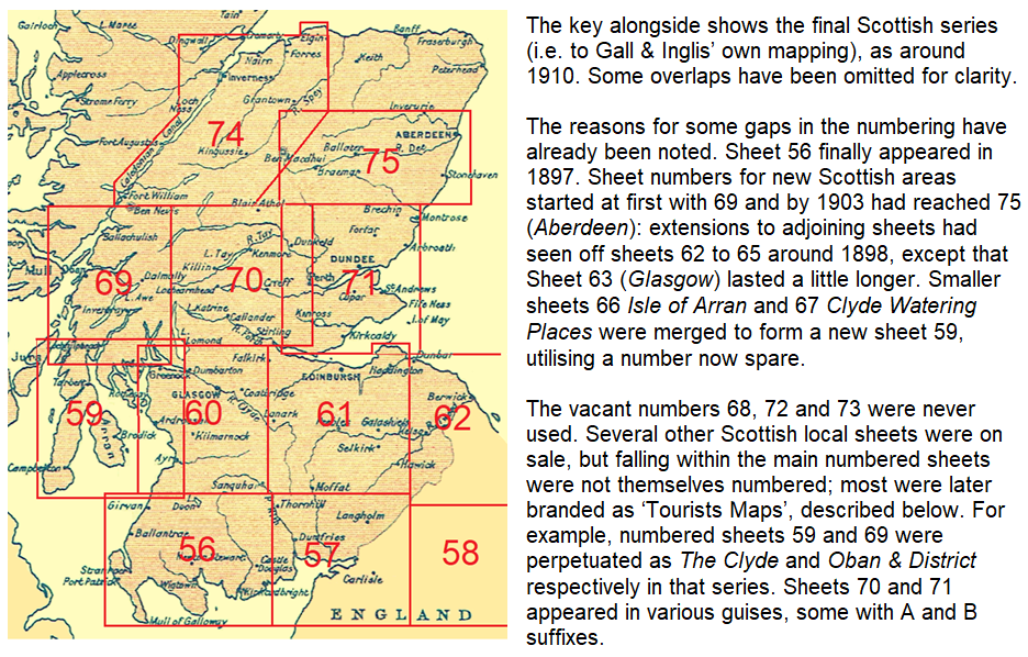
Gall & Inglis’ Own Numbered Half-inch Maps
In the 1890s Gall & Inglis produced new half-inch maps, extending the numbering and range of the Cruchley series further north, eventually reaching Inverness and Aberdeen, with new sheet numbers 69 to 75 (numbers 66 to 68 left blank for intended sheets). The same new mapping gradually replaced that of the old Cruchley series in Southern Scotland and Northern England, initially retaining the numbers (if not the exact boundaries) of the sheets they replaced. As such the firm found itself marketing both these and the northernmost Cruchley sheets for the same area.
The replacement and additional non-Cruchley sheets were incorporated with them for marketing purposes as a single series. By 1908, when the catalogue described it as “The Great 75 sheet ‘Half Inch’ Map of England & Scotland”, these new Gall & Inglis productions were described thus:
New Reduced Ordnance Series… a
series of entirely new Maps are now being issued: sheets published 35, 41 – 44,
47 - 50, 52 - 54, 56 - 62, 69 – 71, 74 & 75
These new sheets were priced at 1/- and 1/6d on cloth. The maps highlighted main roads in red but lacked contouring and showed very few road spot heights, in fact next to none on the English sheets, save within such parts of Cumberland and Northumberland as had already appeared on the Scottish sheets. This paucity of information reduced their value to cyclists compared to their rivals’ products. A footnote to the catalogue stated ‘The above maps are to be had in nearly every town and watering place, often with a local publisher’s name. In that case, the words “Gall & Inglis, Edinburgh” appear at the right-hand bottom corner.’
As well as these ‘standard’ replacements of the old Cruchley sheets, versions with additional information for cyclists closely followed – the half-inch ‘Safety’ (later ‘Graded’) edition. These are covered in a following section.
.jpg)
As noted earlier, the Cruchley maps for Wales and all but northern England were never replaced by this new mapping, but remained on sale until the 1920s.
Gall & Inglis Tourists Maps
Gall and Inglis’ own mapping never extended beyond the Great Glen or along the west coast of Scotland; nor, like an earlier invasion of England, came south of the Trent. The numbered Sottish sheets were largely duplicated by a number of ‘Tourists [sic] Maps’ based on various centres across Scotland, with one also for the English Lake District. These maps retained the same style as the earlier maps, with main roads coloured (initially brown, later red, a few of the secondary roads dashed-red). Some later had steep hills marked on them, as on the graded maps to be described. These Tourists Maps gradually superseded the numbered sheets based loosely on the old Cruchley sheet boundaries and were still being sold, with roads updated, into the 1940s. Internet copies of some of these and other Gall & Inglis maps may be viewed on the National Library of Scotland website, though some of the attributed dates ignore later road improvements. Gall & Inglis half-inch mapping was also used for William Porteous & Co.’s Road Map of 70 Miles about Glasgow, which went through several editions.

Href5
Gall & Inglis Small-scale ‘Safety’ or ‘Graded’ Maps

A Gall & Inglis ‘Safety’ map of England & Wales, in four sheets at 10 miles to an inch, 1s per sheet on cloth, had been advertised in 1891, but seems not to have attracted much attention. Although main roads were highlighted in colour, together with dangerous hills, the map did not attempt to distinguish surface quality and was thus only one of several similar products. However, a ‘Safety’ road map of Scotland, on the same scale in one sheet, appeared in 1894 (1/-, 1/6 on cloth), with different categories of surface quality indicated for 9,000 miles of road:
Since the invention of the “safety” cycling has become more popular than ever, and it is easy now to scour over all the country with these excellent and easily ridden machines. Cyclists will thank Messrs Gall & Inglis, Edinburgh, for the first-rate “Safety” CYCLING MAP OF SCOTLAND which they have just issued. It has been compiled—and as far as appears most successfully —with the view of enabling tourists to ascertain a glance the quality of the roads in any district in Scotland. Superior main roads, roads that are good but hilly, ordinary roads, rough roads, bad roads, and very bad roads are clearly indicated by the different kind of markings along their route. A steep hill is indicated by a red triangle, the top of the triangle indicating the top of the hill; and a dangerous hill is similarly indicated by a blue triangle. Altogether it is such a map - handy for the pocket - that no cyclist who ventures into strange parts should be without. We observe that the dangerous bills at Berriedale, Dunbeath and Latheronwheel in this county are carefully marked, and it is shown that apart from a piece of hilly road between Helmsdale and Berriedale the roads in the county are of the very best kind for the enjoyment of cycling.
Review in the John o’ Groat Journal, 20 July 1894
Alongside the 1894 Scottish map, the four England & Wales regional sheets were reissued to the new, greatly enhanced, specification. From 1900 England & Wales were also available on a single sheet at 15 miles to an inch whereupon the four regional sheets were labelled ‘Large Scale Edition’, though this subtitle was later dropped. The base map in both cases was the same, being that also used for the key maps in the Contour Road Books – that for England & Wales an old 15m to an inch Weller map.
Whereas when first introduced the maps had been titled “Safety” Maps, the maps were now branded “Safety” or “Graded” Maps, the addition reflecting the more relevant characteristic of the map as bicycle brakes and road surfaces improved. At some date after 1906 the cover title on the maps was again changed to simply ‘Graded Road Map’. The title on the index maps remained unchanged, at least for some time.

In August, 1900, the weekly periodical Cycling noted the publication of the single-sheet version of the England & Wales “Safety” map, with a not wholly laudatory review. The following month, however, they were to announce a new edition of their own-branded map of England & Wales for 1901, one that “Shows the quality of 28,000 miles of road; marks 1,700 dangerous hills” – that is, the Gall & Inglis product! This was advertised by Cycling under its own name through to WW1, except for a few months in 1909-10 when a Bartholomew product was substituted. Cycling (and its sister publication Motor) was also to use own-branded versions of Gall & Inglis's Strip Maps and Contour Road Books.
Later, Gall & Inglis were to issue the England & Wales single sheet, as a “Large Scale Edition” on the same ten miles to an inch scale of the regional sheets, rather than its original 15m to an inch scale The base map remained the same. This single sheet was branded as Inglis’ Safety Map, rather than Gall & Inglis’.This sheet was at one time produced in double-sided format, on linen , but post-WW1 reverted to single-sided in a taller folded size. Despite post 1912 catalogues frequently listing it as being on the 15m scale, it was undoubtedly on the larger.

Href6
Gall & Inglis Half-Inch to a mile ‘Graded’
Maps
From 1898 several of the Scottish (and later northern England) half-inch sheets were also produced in the ‘Graded’ series, versions of the standard maps (Gall and Inglis’s own, rather than Cruchley’s), coloured to give information on road quality and hills for cyclists. In effect, they took over the ‘Cyclist’ pocket editions of those maps. Colouring broadly replicated that of the smaller-scale ‘Safety’ maps (though from the start they were known as ‘Graded’ maps) and similarly evolved over time. Roads were categorised as Superior (yellow), Good (brown), Hilly, Inferior or Cross Roads (pinkish red) and Bad or Rough (blue). Dangerous and ‘Stiff’ hills (later categorised as Bad and Steep respectively: often the terminology on the cover differed from that on the map and even between front and back covers) were marked with triangles, although one had to look carefully to see whether an ascent or descent was indicated for the direction of travel. The maps had ‘waterproof’ covers and initially were un-numbered. Like the small-scale ‘Safety’ maps, a later addition to the roads category was the indication of those with ‘Car Lines’ (i.e. tram lines), shown in purple.
The maps bore the words:
In preparing this Map every road is carefully compared and coloured to show tourists which roads to follow by preference. This “grading” of the colours has been done with a view to distinguishing the superiority or inferiority of a road, to those in the immediate neighbourhood, rather than to its intrinsic quality. Any road that is not coloured should be counted as bad.
The Yellow Roads are the best routes to follow, the Brown are the ordinary main roads, the Red are inferior, hilly or merely narrow cross-roads, frequently with short stiff hills, not long enough to be dangerous.
The grading of the colours enables the tourist to choose the best roads, and when out for a short spin to select any cross-road to return by, with the certainty of finding it accurately marked, thus removing any element of uncertainty as to whether the road is a cul-de-sac or not. This accuracy enables everyone to use the Map with complete confidence.
Bad Hills, Stiff Hills, Milestones, Summits, being noted down, the Tourist has much necessary information on the Map itself regarding the road, which is not available in the majority of Maps.

Although lacking contours (although they were of course complemented by the publisher’s Contour Road Books, described below), in the main they were attractive and competent cycling maps. However, it could be difficult to distinguish between the red and brown colours, which covered the vast majority of the roads, let alone the purple, while the yellow roads which should have taken precedence were less prominent than the others and hard to pick out in poor light - this colour had been introduced but soon abandoned for the small-scale 'national' Safety maps.
The choice of grading seems somewhat arbitrary: taking the Lake District as an example, the only ‘Bad’ roads shown are the link between Little and Great Langdale, via Blea Tarn, and the top section of Honister Hause. The Wrynose and Hardknott Passes were implicitly ‘Bad’ by being uncoloured, along with all other minor inter-valley routes. ‘Dangerous Hills’ smother the map: the lane north of the Hawkshead ferry along the west shore of Windermere to Wray, which I have always found an innocent potter, is branded as a series of such hazards.
.jpg)
Expansion of the Graded Series was slow and it never got further south than the Chester – Grimsby line, as Graded versions were only created for most but not all of the sheets produced to Gall & Inglis’ own new half-inch mapping, rather than the inherited Cruchley versions. Whereas the CTC-revised Bartholomew half-inch series for Great Britain had been completed in 1903, by 1907 only seven of the potentially 75 Gall & Inglis half-inch sheets were available in ‘Graded’ editions, and only fifteen by 1914. The later sheets retained the numbers of the old Cruchley maps they replaced, but generally covered a larger area. (sheet size typically 25” by 30”). Dates of first publication of the 'Graded' editions, as far as I can ascertain, are
48 West Yorkshire = 1915
50 East Yorkshire = 1923.
52 Lake District = 1914
53/54 North Yorkshire (combined sheet) = 1913
56 Galloway & S. Ayrshire 1898
57 Dumfries & Carlisle = 1907
58 Newcastle = 1912
59 Clyde, Arran, Kintyre (later Clyde) = 1911
60 Glasgow & Ayrshire = 1901
61 Edinburgh District = 1900
62 The Borders = 1911
69 Oban District = 1911
70 Central Perthshire (later Perthshire) = 1902
71 Fife, Forfar & E Perthshire (later Fife & Forfar) = 1899
74 Inverness, Spey & Caledonian Canal (later Inverness District) = 1914
75 Aberdeen & Deeside = 1903
Although map areas generally reflected those of the main half-inch series, the early sheets did not initially bear numbers.
East Yorkshire, the last to appear in 1923, covered the area of old Cruchley 49 & 50. Sheet 53-4 (North Yorkshire as one sheet), was later sold un-numbered as such. Sheet 62 The Borders extended into Northumberland and considerably overlapped Sheet 61. Sheet 47 Lancashire in its Graded format also covered parts of other Cruchley sheets to give full county coverage; however, this sheet seems to have been dropped in 1927. As only the other sixteen were still advertised in 1930, seventeen must represent their ultimate total.
When introduced, the Graded maps were priced at 1/6 and were only ever available on cloth. From 1916 seventeen sheets were advertised, price 1/8d, then (1919) 2/-; some now titled on the map and in advertisements as Inglis’ rather than Gall & Inglis’ Graded Maps. In 1928 the maps were 3/-, on cloth, the same price as Bartholomew’s half-inch maps. This was later reduced to 2/6 as the age and quality of the maps fell behind those of their contemporaries. The road and hill classification had evolved: the final blue category was now ‘rough roads’, and hills were classified as ‘steep’ and ‘very steep’. The ’car’ symbol and purple colour for tram networks were dropped, as these systems were rapidly yielding to the motor bus. Some sporadic revision to the main road network took place up to WW2.
.jpg)
Href7
Other Gall & Inglis Maps, Including Other Publishers’ Editions
In 1889 the company was advertising a Tourist Map of England & Wales, on the scale of 15 miles to an inch – plain 6d, coloured 1s, on cloth 2s. This was originally produced by Edward Weller and seems to be on the same base as their Travellers’ Map of England with the Railways.
Cruchley had produced a variety of maps of London and these were perpetuated by Gall & Inglis. These included The Reduced Ordnance Map of London; (35” by 40”), The Handy Map and Guide of London; The 6d Plan of London; The Pocket Map of the Suburbs of London (1” to mile, ‘from the latest Ordnance Surveys’); The Environs of London; London to the Kent and Sussex Watering Places; 25 Miles Round London and four ‘Cycling & Touring Maps’, on the half-inch scale, by Cruchley: 60 miles North/ West/ East/ South of London. These last were still being advertised in 1927. In 1909 Gall & Inglis produced a double-sided map, with central London on the one side and a half-inch map of the environs on the other.
Href8
Dating Gall & Inglis Maps
It is difficult to date Gall & Inglis own half-inch maps. The print code (if present) is unrelated to date, prices are not shown, covers are unhelpful and railway revision unreliable, with line and station closures ignored. Only major road schemes, such as Kincardine Bridge (1936) acknowledge the passing of the decades. The earliest reference to the half-inch series I have found is 1889, for the Edinburgh, Arran, Clyde and Scottish Lake District maps, with only the last actually described as ‘new’ that year. The 1893 publication of Fife, Forfar and East Perth District is noted (commenting that main roads were coloured: interestingly, this has hill-shading not seen on other sheets nor perpetuated, though some old hill-shading was carried over from the Cruchley maps for parts of Dumfriesshire and Arran); by 1897 the new numbered sheets 56, 69, 70 & 71 had appeared.
With the publication of the Contour Road Books (commencing with Scotland in 1896) a footnote ‘plug’ for the books was added to the various half-inch maps or covers and progress on these, the Graded Maps and the publisher’s strip maps are the best dating guide – at least to the date of the covers. The various changes in address of the firm have been given at the start of this page and these give a broad date range of the map – or again the cover. Many maps include adverts or notes on the progress of the Contour Road Books and Strip Maps, and in the following sections on those products I have tried to give as much dating information as possible.
Railways, initially uncoloured parallel lines, were replaced by a ladder style (as retained for mineral branches) and gradually (1900 – 1910) by solid black, some skipping the intermediate stage. However, the ladder style was retained on some earlier maps (including their ‘Graded’ editions) until their demise and often more than one style would appear on the same map. One useful tip - Gleneagles station, lying on several sheets, was known as Crieff Junction until 1912.
About 1910 the initial brown for roads was replaced by red, with a few secondary roads shown dashed red (on some sheets dashed red was reserved for popular mountain paths). Maps produced under local publishers’ names often retained older styles. Even the titling on the maps varied: many bore no title at all, others were branded as ‘Inglis’ Cycling & Touring Map’ on covers and map heading (still with the old ‘Cruchley’ sheet number), some with ‘Gall & Inglis New Half-Inch Map’ while other variations arise. Some later editions of the Tourists maps had roads uncoloured – WW2 austerity? They are recorded as being on sale as late as 1952, though I suspect they were old stock last revised before WW2. The coloured ‘graded’ maps were certainly revised into the 1930s, though new roads were often shown rather crudely. Aerodromes and radio transmitters were some of the few new features to be added. The maps never showed MoT road numbers, golf courses or youth hostels – a few additions that could have made the maps more customer-orientated at trivial expense.
Much of the foregoing also applies to dating the small-scale ‘Safety/Graded’ national maps. This cannot cannot be precise, except for the early years, when the rapid changes in style, as well as the density of roads included, helps. The Scottish examples on the National Library of Scotland website are useful. Initially named ‘Safety Cycling Maps’ on covers, this changed to ‘Safety or Graded Road Maps’. Expansion and pricing of the Contour Road Books, often advertised on covers, is another dating clue. Railway denotation style, as for the 'standard' maps, is haphazard and revision after about 1905 is only patchy and an unreliable dating tool.
Href9
Gall & Inglis Contour Road Books


The first volume to appear, in 1896, was the Contour Road Book of Scotland, edited by Harry R. G. (Robert Gall) Inglis, 1869 – 1939, son of Robert Inglis, and husband of James Gall’s granddaughter. Harry Inglis seems to have been the driving force in the firm’s cycling-related projects, such as the contour road books, the strips maps and the ‘graded’ road maps. He was an authority on the old roads and maps of Scotland and in 1933 published Scottish Hill Passes, complementing the Contour Road Book by covering pedestrian-only routes, many of which became popular with rough-stuff cyclists. Later editions of this and the road books were revised by Harry's nephew, Robert M. Gall Inglis.
The companion three volumes of Contour Road Books covering England and Wales appeared in 1897 (North), 1898 (South-East) and 1900 (Western England & Wales). Each was available in a standard format and a lightweight and compact version on ‘fine India paper’ – easily slipped into a cyclist’s pocket. The Western volume was preceded by an 1899 ‘temporary’ volume entitled Devon, a misnomer as actually covering the area south and west of Bristol. This must have been popular, as it was perpetuated after completion of the full Western volume and in 1904 was joined by a similar volume just covering the Welsh routes. Both the Wales and the ‘temporary’ Devon volumes were still being advertised in 1925. A combined volume of the three regional volumes for England appeared in 1901; also available as a luxury edition including town and environs plans. In 1903 a single volume for Great Britain was published, effectively the four constituent parts bound together. From 1906 two further options were available: Scotland bound with northern England, and the South-East and Western volumes bound together. These duplex volumes were the first to be withdrawn, not appearing post WW1.


The route descriptions listed detailed locations and gradients for all steep hills – taken as those steeper than 1 in 25 (4%), which would be considered an unremarkable gradient with today’s brakes. “A descent does not become dangerous until it is 1 in 15 and then only with a sharp turn, but with anything steeper the danger increases”. Incidentally, for horse-drawn traffic a gradient of not more than 1 in 30 was considered desirable (though often infeasible) for newly-built roads: this is by coincidence the recommended maximum gradient for motorways.. By comparison, today’s OS Landranger maps indicate only those hills steeper than 1 in 7. In the uphill direction, “Cyclists usually walk up a hill of 1 in 17” appeared as late as 1927 – hardly true by that date, with the wide but far from universal adoption of multiple gears (as many as five!).
Extracts from the ‘Contour’ books had appeared in Gall & Inglis’s Short Spins around Edinburgh – “A local Supplement to the Contour Road Book of Scotland” (1897). This was followed by Short Spins around London (1903-04: later assimilated into the Contour series as London North and London South, and from 1912 published by the weekly Cycling paper as its 2-volume Road Book & Guide to the Environs of London).
The sturdy Contour Road Books proved extremely popular, with the Scottish volume going through new editions almost annually in its early years. The following, taken from a review of the 7th edition (1905) makes some interesting comments on the development of the Scottish road network at that time:
- The seventh edition of this well-known and useful book for cyclists and motorists has just been issued by Messrs Gall and Inglis. While varying little from the general lines of the first edition, it has undergone a very extensive overhaul and now contains plans of about 50 more roads, and also has maps of Perth, Aberdeen, Dundee and Inverness. The ferry charges are up to date with all available information for motor cars, and the book has generally undergone careful revision both in convenience of arrangement, ease of reference, and practical utility. It is the intention of the publishers to issue a motor supplement containing the prohibited roads for motors when the "Orders" are complete.
Perhaps the most interesting feature of the Scottish roads is the improvement that has taken place in what was at one time a most trying experience for Scottish cyclists - the road from Blair Athole to Kingussie over the Grampians; and Glencoe. The latter is vastly improved in quality, while the former seems to be recovering its pristine glory as a fast mail road, for on the Perthshire side the surface is all that could be desired, and in Inverness there are some stretches of fine, smooth, gravelmended road. Rumour has it that nearly 100 motor cars have been crossing the Pass in one summer's day, but probably quarter of that number would be more accurate. Curiously enough the other short Pass from Tyndrum to Dalmally which was one time an "experience" and a few years ago was put in order, has now relapsed into its old loose state. The great barrier to Braemar still exists in the Devil's Elbow, Glenshee. Many, many years ago Aberdeenshire improved its side of the Pass; and it now remains for Perthshire to get rid of this dangerous comer. The bad piece at Bridge of Cally on this road has now been made a splendid piece of road engineering, it is to be hoped that the other will soon find favour in the eyes of the authorities. The new list of ferry charges shows that there are a goodly number of ferries where motors cannot be carried. One in particular - Connell Ferry - is the direct result of the new railway to Ballachulish, as the "big" boat has been taken off. - St Andrews Citizen, 20 May 1905.

The Gall & Inglis Contour Road Books crop up regularly for sale on the internet (often at silly asking prices). Some of the volumes have been reprinted in facsimile. A few editions are available to read online, for example Internet Archive

Href10
Gall & Inglis Strip Road Maps
Some of the profiles from the Contour Road Books were also used alongside a concertina strip of half-inch mapping in a series of maps covering the most important routes from London (also between some provincial cities, Land’s End to John o’ Groats, Edinburgh to Inverness), for the use of cyclists. They had their origins in a number of cycling maps on the half-inch scale produced by Harry Inglis (son of Robert), commencing with The London to Edinburgh Road: The Great North Road and East Coast Route in 1893. These were followed in 1894 by The Bath Road, The Holyhead Road, The Exeter Road, and Land’s End to John o’ Groats. They were originally titled ‘Continuous Strip Maps’: Each Map is a continuous strip of our ½” Map, joined together so as to produce a neat Map pocket size, showing the Road, and about 6 miles either side’. In concept these maps harked back to the earliest road maps of Britain, the strip maps produced by John Ogilby at the end of the 17th century, though these earlier works showed and gave detail only for the road in question, not detailing those aside of it. These maps were soon augmented by accompanying road profiles, derived from the Contour Road Books, commencing with the duplex map of the Brighton and Ripley (i.e. Portsmouth) Roads in 1899.

The maps originally went up to sixteen feet in length. By the time of the1904 catalogue about twenty routes were advertised, but these were later subdivided to give a more manageable length of eight feet or less, all priced at a shilling. Those for the southern half of England retained a Cruchley base.
For some years from 1903 these maps were rebranded as ‘Strip’ or ‘Motor Route’ maps (although, strangely, not titled as such in all publicity). The addition of ‘Motor’ reflects a marketing link to the new periodical of that name published by Temple Press, who were concurrently publishing some other Gall & Inglis products under their ‘Cycling’ brand name, including from 1904 the “Cycling” Strip Route Maps. The Contour Road Books were also marketed as "Motor" Contour Maps for a while.
The original Routes 1 and 2 (Land’s End – Worcester and Worcester – Edinburgh) were to be incorporated in other routes, although a 5-section Land’s End to John o’ Groats book was retained alongside (price 5/-, the maps thirty-two feet long!). 1906 saw the addition of 7 The Oxford Road, 9 The Midland Road and 18 Birmingham – Lancashire & N. Wales, the last with an expanded Route 8 replacing the former Route 19. Thereafter there were no increase in numbered editions, though there were some expansion and repackaging of the roads covered within them, away from a single ‘A to B’ route, and changes in title. For example, Route 21 The Carlisle Road, gave ‘Liverpool, Warrington, Manchester, or Leeds, via The Lakes [or Shap] and Carlisle, to Dumfries, Glasgow, or Edinburgh’. With two roads being offered to Edinburgh, I make that a total of of 32 potential routes! Although route numbering went up to 28, gaps indicate that some contemplated maps never reached fruition – East Anglia and most of Wales were never covered. This suggests as a series they were not over-successful, particularly in post WW1 years: nevertheless they remained on sale until the 1930s.
An eight-foot long map would seem to be somewhat unwieldy to inspect on top of the Cheviots on a wet and windy day, but actually the book format meant that it was always open at one page at a time, so arguably less awkward in use than a conventional map. However, the value of strip maps would, I think, be rather limited, as they were confined to one route and one on which navigation would not be difficult. Nevertheless, the Strip Maps proved popular in their day. W. & A. K. Johnston brought out a rival London – Edinburgh strip map in 1907, utilising its 3m to an inch mapping._____________________________________________________