BARTHOLOMEW
Top of Page Href
Bartholomew Cycling Maps

The following is a detailed history of Bartholomew’s cycling map products. It was long standard practice amongst all map publishers for Scottish maps to be produced, marketed and sold separately from those for England and Wales. As a result, the bibliography of the Bartholomew England and Wales maps is best treated separately from those of Scotland, though to some extent they are intertwined. Given the dominance of the quarter-inch and half-inch scale maps for cycling purposes these too are also best considered separately.
- Overview
- Bartholomew's Quarter-inch Maps for A. & C. Black Click here
- Bartholomew's Small-scale National Maps Click here
- The ‘Pocket’ Series for W. H. Smith and Others Click here
- - Development through the 1880s
- - 1891 renumbering of the Index
- - Into the 20th Century
- Bartholomew’s Half-Inch Maps (Scotland) Click here
- - Scottish First Series, 1875
- - Scottish New Series, 1890
- The Bartholomew - Baddeley Connection Click here
- Bartholomew’s Half-Inch Maps (England & Wales) Click here
- - Early Half-inch Maps Predating the National Series
- - Commencement of a National Series of Half-inch Maps
- - Bartholomew’s War Office Maps
- - Special Cyclists’ Map Derivatives
- The England & Wales National Half-Inch Series Click here
- The Combined Great Britain Series Click here
- - From Metrication to Withdrawal
- Time Line and Changes Summary – Bartholomew Half-inch Map Series Click here
- Bartholomew’s Quarter-Inch Maps of Scotland Click here
- - Bartholomew’s Quarter-inch Scotland, 1862 - 1911
- - Bartholomew’s Quarter-inch Scotland, 1910/11 onwards
- Bartholomew’s Quarter-Inch Maps of England & Wales Click here
- - Bartholomew’s Quarter-inch England & Wales, 1866 - 1927
- - Bartholomew’s 1927 onwards Quarter-inch Gt Britain Maps
- Bartholomew’s Quarter-Inch Maps of Ireland Click here
Overview
- For maps I bought rather a complete set of those made by Bartholomew on a half-inch to a mile. They are so exactly printed that they show the slightest curve of road and all changes of elevation. Often they marked an alternative road that saved a hill, or by a thinner line they took us from the thicker traffic into the quieter lanes. It is the byroad in England that one should choose, for its surface is as smooth as that of the larger roads and no motors disturb its peace.
John Bartholomew (1805-1861), son of an engraver, had been producing maps of all scales since 1826, for private clients but also for guide books and atlases for such firms as John Murray, George Philip and Adam & Charles Black. Until 1860, when he set up his own printing presses, his map business was restricted to providing the finished engraved plates to other publishers for printing, normally without any printed acknowledgement of the Bartholomew name.

As noted above, John Bartholomew Junior began by producing maps branded by the names of other publishers such as W. H. Smith, G. W. Bacon and G. Philip in England, and Adam & Charles Black of Edinburgh. In 1888 his son John George Bartholomew (1860-1920) succeeded him in running the firm and the next year the company moved from Chambers St to new premises in Park Road, Edinburgh, to be known as the Edinburgh Geographical Institute. Maps were now to be marketed under the Bartholomew name, though commissions for others continued to be a major part of the firm’s work. John George Bartholomew was in turn succeeded by his son, John (Ian) Bartholomew (1890-1962). The company was run by Ian’s sons until the 1980s.
What was known as the ‘New Series’ of half-inch maps of Scotland came out between 1890 and 1894, and this time were published as Bartholomew maps and had the new contour-colouring format. At the time there was no corresponding half-inch coverage of England and Wales save for a few pioneering sheets, though quite extensive areas of mapping on the half-inch scale had been produced by Bartholomew for inclusion in tourist guidebooks, generally with hill hachuring.
The fore-runners of what became the England and Wales half-inch national series were twelve sheets produced between 1892 and 1897 and scattered by name within the general Bartholomew catalogue. In 1897 these were incorporated into a series extending over the whole of England and Wales, completed in 1903 and complementing the Scottish series. These clear, attractive and (at the time) very up-to-date maps immediately became the cyclist’s favourite. The half-inch scale was ideal for cycling, as it enabled all country roads to be shown, as well as all arteries though towns. The contour-colouring gave an immediate idea of the difficulty of the terrain, while also indicating the scenic potential of an area.
Bartholomew’s half-inch maps were based on the Ordnance Survey's latest editions of their one-inch maps and initially titled ‘Reduced Ordnance Survey’. The original generosity of the Ordnance Survey in allowing commercial map producers ready access to its own product was gradually replaced by royalty payments, a system to which Bartholomew refused to subscribe on the basis of its longstanding usage of OS information, and that as the OS was publicly funded such information should be freely available, provided publishers such as themselves were not directly reproducing OS maps. Royalty payments were also set to become much higher than they had been. The outcome was that further revision of the Bartholomew map depended on ad-hoc contributions from users such as cyclists, local authorities and others. This was not such a disadvantage as it might seem: at the half-inch and quarter-inch scale new roads could be shown sufficiently accurately from such information: it was minor changes that escaped the Bartholomew eye. As a result, whereas the maps were updated to show major developments such as reservoirs and major new roads (often more promptly than the Ordnance Survey itself), lesser detail such as the status of minor roads and byways grew progressively out of date. In rural areas the map of 1970 was basically the map of 1900 - but that erstwhile lane might have become a tarred road, degenerated to a cart track, or simply disappeared.
In the 1970s, following the advent of the 1:50,000 Ordnance Survey maps to supersede the former one-inch series, Bartholomew enlarged its half-inch maps to 1:100,000, but the underlying map was unchanged – indeed, the widening of the contour interval to 50 or 100 metres and the omission of many spot heights meant less information helpful to the cyclist was provided. The shift to off-road cycling meant that the new generation of cyclists simply had no need for this type of map. With sales falling, the concept of a national series was dropped and what sheets survived were promoted individually. Eventually even these dropped out of print.
In 1989 Bartholomew became part of the Harper Collins group.
Bartholomew's Quarter-inch Maps for A. & C. Black
The first series of maps to be produced by Bartholomew to play a later role as cycling maps were twelve sheets making up a quarter-inch map of Scotland, which appeared in 1862. This was for the well-established publishing firm of Adam & Charles Black, in Edinburgh, and hence bore the Black name rather than Bartholomew - Black’s New Large Map of Scotland. These were followed in 1866 by a similar map, available in sixteen sheets, for England & Wales. These were to form the basis of innumerable cycling maps over the next sixty years. The initial maps are covered under the Adam & Charles Black page, and in their later incarnations in the sections on the Pocket Series and Quarter-inch maps following on this page.
Bartholomew's Small-scale National Maps
Some of Bartholomew’s longest-lasting productions were small scale (taken here as eight or more inches to the mile) national maps, covering Scotland, England & Wales, Ireland or the British Isles. As well as atlas sheets, these were also available as ‘travelling maps’ to assist those making or planning journeys, which increasingly involved rail rather than road travel. This changed in the 1870s, with the first touring cyclists. As only the main roads – mostly former turnpikes – were suited for cycling the lack of detail on cross roads was not a loss. Such maps were also of value in tour planning, and it was mainly as a planning tool they were to serve cyclists over the next hundred years.A Map of Scotland had been produced by Bartholomew for George Philip & Son circa 1870, 100cm by 63cm. Included was an index. Colouring was by county and style was similar to the county maps produced by Bartholomew for Philips. Various other small-scale national maps were produced by Bartholomew for a number of atlases, but these not concern us.
In 1880 was published a new Scotland map, a much more up-to-date production, on the scale of ten miles to an inch – Bartholomew’s New Tourist Map of Scotland (the National Library of Scotland copy is wrongly ascribed to 1890: it predates their other editions). Maps in identical style were produced for England & Wales, and Ireland.
The British maps appear to have been largely based on the 1860s quarter-inch maps produced by Bartholomew for Adam & Charles Black, as described on the A. & C. Black page. As a result, they perpetuated some errors in what was classified as ‘driving’ roads. In Scotland, the old military road over the Corrieyarick Pass, abandoned in the 1830s, was included, as well as various unsuitable roads in the Borders. Many of the errors on the quarter-inch map in Devon and elsewhere which I have described on the Black Museum page also appeared on the 10-inch map, and could still be found on 20th century editions.
In 1885-6 the three national maps were reissued with orographic, i.e. contour-coloured, layering.


An entirely new small-scale map by Bartholomew appeared in 1907, which, as with the earlier map, was to have a long production life, and likewise was to crop up up in all sorts of places. This was Bartholomew’s Motor Map of the British Isles, so covering both Gt Britain and Ireland in one sheet. Whereas the ten miles to an inch map was a jack of all trades production, being used, for example, in geological and naturalist formats, this new map was solely aimed at the traveller, initially showing roads only (though a version with the addition of railways was later produced). It included road distances, so just about creeps in as a planning map for cyclists. The initial scale was 16 miles to an inch, though this could be adjusted to meet client requirements. For example, it was used in the Newnes (later Bartholomew) Road Atlas to cover those parts of Scotland not covered at the full 4m to an inch scale, as well as for the maps of Ireland. The individual map was still being sold in the 1960s as Bartholomew’s British Isles Motoring Map.

href1
The ‘Pocket’ Series for W. H. Smith and Others
As it had for Scotland, Bartholomew had produced a quarter-inch (1:253,440) map of England & Wales for A. & C. Black – Black’s New Large Map of England. This first appeared in 1866, primarily as a wall map, but it was also available in the form of sixteen individual sheets. Because of their origin as segments of this national map, some of these sheet areas were rather inconvenient. An index plan and further background is included on the A. & C. Black page.
The first Bartholomew maps published for England and Wales to be generally available were quarter-inch to the mile sheets (1:253,440), being smaller lithographs taken from the Black's maps and centred on major towns and cities. First off the mark with such maps seems to have been Houlston & Sons (see that page), but the most popular series was that for W.H. Smith, the ‘railway booksellers’ and generally advertised as W.H. Smith & Son’s Reduced Ordnance Map’ – later the ‘Pocket’ Series. The same maps were also published under the names of other publishers over the years, though W. H. Smith seemed to have cornered most of the sales. The firm had been quick to spot the potential of bookstalls at railway stations, and negotiated franchises with the larger companies. With their numerous outlets, W. H. Smith developed into one of the most successful companies in Victorian England and was the natural outlet for travellers’ maps. Thus it is appropriate, if not strictly accurate, to denominate this series as W. H. Smith maps. It is also convenient to cover the history of this series through to its effective demise in the 1900s.
The base mapping was, by arrangement with A. & C. Black, taken from their 1866 map referred to above – indeed, Black’s guidebooks advertised these rather more often than Black’s own quarter-inch maps. Whereas the Black maps comprised sixteen abutting sheets, the new maps were smaller lithographed copies to new boundaries. They must have made their first appearance some time after 1866 (the rival Houlston & Sons’ maps, from the same source, first appeared in 1868), but I have been unable to tie a date to an index earlier than 1871, by when over forty maps were being advertised. Updates (or replacements) were made to the set of sixteen original map plates, so where the localised maps straddled a plate boundary some very slight discontinuity could be found, particularly where one plate had been updated and the other hadn’t.
To avoid this section being over-burdened with details of individual maps, a schedule of all those appearing up to 1900 is included under W. H. Smith on the Miscellaneous Publishers page (this link will open in a new window).

These W. H. Smith maps were in protective covers of red cloth-covered cardboard. The map title was given on an attached cream-coloured sticker, e.g. W. H. Smith’s Reduced Ordnance Survey Map of ------------ No reference to Bartholomew was made on the cover, though J. Bartholomew Edinburgh appeared, in small lettering, below the map itself. Prices were 1/- mounted on linen, a paper-only option was not advertised, at least by Smith’s. The quarter-inch sheets had a standard size of 13” x 18¼”, giving an area of 52 by 73 miles (advertised as 52 by 70 miles). In view of the area covered some of the titles were a bit misleading or unimaginative: one might not realise that Environs of Aldershot stretched from London to Southampton!
Although there was a mix of ‘county’ and ‘environs’ in their titles, the same mapping was used throughout, and detail on the ‘county’ sheets covered such parts of neighbouring counties as fell within the sheet borders – unlike the atlas-derived ‘county’ maps by other publishers which showed little or no detail beyond the county borders. The series represents a transition from producing maps of individual counties to a unified series of rectangular sheets to give national coverage. In their earliest style counties were coloured individually, both for the ‘County’ and ‘Environs’ map.

In 1879 or 1880 the original catalogue numbering was dropped, and a single alphabetic list produced, embracing the quarter-inch ‘county’/‘environs’ maps, town plans and other maps.
More quarter-inch sheets were being added, duplicating the earlier maps but centred on different towns. Some pairs of maps, e.g. Newcastle and Northumberland, Norwich and the later Norfolk sheet covered largely the same area. Also naming a major town or city helped improve local sales, such as the Land’s End & Cornwall and Cornwall sheets which appeared in the indexes together (and where the latter map was for a time described as ‘showing Land’s End’, for the benefit of the geographically illiterate). Was the popularity of such rides as Land’s End to London and Land’s End to John o’ Groats responsible? Names on covers, or on the maps themselves, did not always tally with those given in lists or with each other. A few sheets had been renamed – Dorset becoming Dorsetshire, Isle of Wight becoming Isle of Wight & Part of Hampshire. The Lake District map briefly became Lake District of Westmorland & Cumberland, then Lake District & Windermere. Whereas the map title on the cover usually highlighted the central town, e.g. Nottingham and Environs, the title on the map was often reversed, e.g. Environs of Nottingham.
Around 1880 the cover size of the W. H. Smith editions, initially 95mm by 145mm, was increased to 105mm by 162mm or so. About the same time some maps had railways highlighted in red, additional to the county colouring, though this development was short-lived.
href1A
Development through the 1880s
Further quarter-inch maps were still being added, but the main development was the inclusion of maps on the one-inch scale, covering sections of the Lake District. These incorporated the new principle of contour-colouring, which was to become a feature of so many Bartholomew maps. The mapping had first appeared in the sectional maps in Badddeley's 1880 Thorough Guide to the Lake District, referred to in a following section.

From about 1885, the plain cover stickers were replaced by a more elaborate version, including a blue floral pattern. These now had the title ‘W. H. Smith and Son’s series of Reduced Ordnance Maps for Tourists by J. Bartholomew F.R.G.S.’ – the first acknowledgement of Bartholomew on the covers, rather than just discreetly on the map. The indexes inside the covers, formerly entitled ‘Reduced Ordnance Maps’ became ‘Series of Tourists’ Maps & Plans of England’. A subtitle added ‘These Maps are specially adapted to the needs of Tourists and Cyclists’ – an overdue nod to cycling. Around the same time the previous style of colouring each county in an individual tint was dropped for a scheme in which county boundaries were still highlighted, one colour each side, but the main roads were now highlighted in reddish-brown. The index was now sub-divided: as well as the ‘General Series on Scale of 4 Miles to an Inch’, there was a short list of ‘Special, Large Scale and General Maps’, and twelve town plans. No numbering system was employed. All the standard quarter-inch maps (except for Yorkshire) were only available mounted on cloth, price one shilling.
The initial ‘Special Large Scale and General maps’ were all the non-quarter inch maps from the previous list, with among the later additions South Devon on the half-inch scale, the first of three such maps of this title published in quick succession. These half-inch maps of Devon triggered a renaming of some of the quarter-inch sheets of the area.
At some time around 1890, the plain red cardboard covers with blue- and cream-coloured sticker were replaced by a different style, initially on red cardboard as before, but soon changed to blue and of slightly-increased size. These later were of thinner card with rounded corners These had the W. H. Smith name and ‘by J. Bartholomew F.R.G.S.’ etc printed directly onto it. This cover display included the ‘John Bartholomew & Co Edinburgh’ circular logo, enclosing an outline of the British Isles, now topped with a coronet.
href1B
1891 Renumbering of the Index
Where included on Bartholomew-covered maps, or book advertisements the list had been headed as ‘Bartholomew’s Pocket Touring Maps of England’ and later included town maps as a separate list rather than a single alphabetical one, though retaining the numbering. At the same time, someone seems to have realised that Edinburgh, Dublin etc were not in England and so the series were simply referred to as ‘Touring Maps’ by Bartholomew. Those published under W. H. Smith covers had indexes headed ‘W. H. Smith & Son’s Series of Travelling Maps by J. Bartholomew F.R.G.S’. The equivalent John Walker indexes stuck to ‘The Pocket Series of Touring Maps’. Of course, many other town maps, and local extracts of small-scale maps were produced for guidebooks and other customers and so did not appear in these indexes.
The old Black’s 16-sheet series was republished directly under the Bartholomew name in 1893. A new edition in 1897, on twelve more convenient sheets, spelled the ultimate end of the old Pocket Series quarter-inch map derivations. No further sheets appeared after 1896, and by 1908 all but three had been withdrawn, the survivors being Kent (withdrawn 1912), London & Environs (replaced by an entirely new colour-contoured map in 1911), and Yorkshire (still advertised 1925).

The seemingly chaotic collection of quarter-inch mapping forming the bulk of the England & Wales index was at its peak around 1893, with much overlapping of the maps. Four quarter-inch maps covered most or all of Lancashire – 51, 56, 65 and 78, with Southport appearing on all. In that year Bartholomew published its own National Series of quarter-inch maps (actually the sixteen old Black’s sheets of 1866, with revisions, but now solely under the Bartholomew name). This was the beginning of the end of the old locally-based quarter-inch maps still forming the bulk of the Pocket Series, now variously referred to in the indexes as Travelling or Touring Maps. These were withdrawn as the new National Series maps appeared, though, surprisingly, a few new sheets were to appear. These new district and ‘hybrid’ maps/town plans sheets were to have a very short production life.
Other one-off maps on other scales had gradually been added, such as the smaller-scale cycling maps mentioned above, Scottish and Irish maps, as well as a new section - the World Series Maps. One would have been unlikely to find these on your local station bookstall!
An interesting addition was that of The Lake District on the scale of three miles to an inch, this being an update of Bartholomew's first colour-contoured map of 1880. Its appearance in the Pocket Series index was not until 1893 when for a few years it replaced the quarter-inch map of the same name. A 1938 (!) extract utilising this base map is given in the earlier overview to Bartholomew maps.

href1C
Into the 20th Century
1897 had been a pivotal year, with a new much more customer-orientated 12-sheet version of the quarter-inch maps introduced by Bartholomew. The contemporary massive upsurge in cycling was to transform the relatively few sheets produced by Bartholomew on the half-inch scale into a National Series which was to become the firm’s most successful product. The majority of those half-inch maps added to the 1890s indexes were thus hived off into their own series. The subsequent story of these half-inch and quarter-inch National Series are fully described in sections that follow. The survivors of the original Pocket Series, from 1897 described as Pocket Series of Tourist Maps, were termed ‘District’ maps from 1904 within what was now a section of the index (though this name had been used earlier) and most of these had disappeared by 1907. However, there were still one-offs on other scales which were retained and augmented. These seem to have been branded the ‘Survey’ Series, though this name had also appeared earlier. This included such diverse maps as Thames, the River and Durham & Environs.
The following is a (roughly) chronological description, 1898 onwards, of the arrivals and departures of the maps, mostly but not exclusively relevant to cycling. For the history of individual Pocket Series maps before this date see the W. H. Smith section on the Miscellaneous Publishers page.
A London & Environs 1” map had appeared in the index in 1878. This appears to have been later reissued as two maps, London North and London South. Subsequent editions of these were recorded as late as (at least) 1952 for the former and 1941 for the latter, now subtitled Roads and Countryside. By contrast, the London, East and London, South town plans were withdrawn – from these indexes at least - in 1912. A new and very different 1” Greater London map appeared in 1967.

For the 1898 season the numbering of the general series was dropped for the second time. Town plans were listed separately from the maps list.
By 1899 the Ulverston & Furness District and the Grange, Carnforth one-inch sheets had been dropped from the indexes, to be replaced in 1901 by a new Windermere & Morecambe Bay sheet covering largely the same area. The Windermere, Coniston, Grasmere etc sheet, which was also wholly duplicated between this and the Keswick, Ullswater etc sheet, remained in print a few years longer but was absent from the index by 1906.

By 1903 the Half-inch map series of Scotland and England & Wales were both complete, as was the new series of quarter-inch maps of England & Wales. The Irish quarter-inch maps formed their own separately-numbered series from 1904. All these series were therefore removed from what was now the 'Travelling Map' index and indicated through separate key maps showing individual sheet boundaries. Details on the development of these series are given later on this Page in their specific sections.
- Cambridgeshire (withdrawn 1907)
- Hampshire (withdrawn 1907)
- Kent (withdrawn 1912)
- Liverpool & Environs (withdrawn 1907)
- London & Environs (not to be confused with 1” map of same name. Replaced by an entirely new contour-coloured map of the same name in 1911 – see notes on the later quarter-inch series)
- Manchester & Environs (withdrawn 1907)
- Northumberland (withdrawn 1908)
- Somersetshire (withdrawn 1908)
- Surrey & Sussex (withdrawn 1907)
- Wales, North (withdrawn 1907)
- Wales, South-west (withdrawn 1907)
- Yorkshire (still advertised 1925)
Several of these maps had had lives of forty years or so, during which their price remained unchanged at one shilling on cloth (the Yorkshire sheet, being larger, was priced at 2s and was to outlive its companions by some years).
Apart from the Yorkshire and London & Environs sheets, the other remaining small-scale maps comprising the
‘Pocket Series’ in 1906 were
- British Isles Railway Map (later listed separately)
- Edinburgh District (1¼" = 1 mile)
- Edinburgh, Environs (half-inch)
- Glasgow, Environs (half-inch)
- Isle of Wight, with Guide (1" = 1 mile)
- Keswick, Ullswater etc (1" = 1 mile) (last edition 1910 and superseded by Lake District 1” map, 1913, but still advertised later)
- Lake District & Windermere (3m = 1")
- London & Environs Rly Sta. Map (1" = 1 mile)
- London & Environs Map (1" = 1 mile, later contoured) Later (1935) issued as separate north/south sheets
- Melrose Pocket Guide (with map)
- Thames, The River (half-inch. Republished 1908, rebased on the new half-inch series mapping)
- Windermere & Morecambe Bay (1" = 1 mile)
The 1906 index also shows two additional half-inch maps, Aldershot
District and Salisbury Plain District which were still being
advertised in 1925. These had been produced for the War Office a few years earlier, and are described in a following
section.

Other maps relevant to cycling listed in 1910 were
London Northern District (half-inch, this appears to be the last of the original five ‘Special Cyclists’ Maps’ of 1902 as described below)
This new Lake District sheet incorporated, and ultimately superseded, the Keswick, Ullswater etc sheet and the northern part of the Windermere & Morecambe Bay sheet, which in turn had superseded earlier, smaller, sheets.. About half of the Windermere & Morecambe Bay sheet coverage fell outside the new Lake District sheet and it was still advertised in 1925, alongside, surprisingly, the technically superseded Keswick sheet.
Href2
Bartholomew’s Half-Inch Maps of ScotlandScottish First Series, 1875
Advertisements on the back of Bartholomew's Maps of the 1940s proclaimed
"BARTHOLOMEW'S HALF-INCH SERIES
This map has a unique record among cartographical publications. The first sheets were brought out in 1875 with simple colouring by counties. At the Paris exhibition of 1878, Mr Bartholomew showed specimen sheets in layer or contour-colouring. That system was eventually adopted for the whole publication, which thus became the first topographical series in any country to use it. Based originally on the Ordnance Survey by permission, it is now kept up-to-date by its own service of information and is generally acknowledged as the most up-to-date of any map in the country."
The half-inch maps for Scotland produced by Bartholomew from 1875 onward were published by A. & C. Black in Scotland and George Philip (and probably others) in London. They formed a national series for Scotland, completed in 1886. I have referred to these as the First Series, but at the time they were known simply as ‘Reduced Ordnance Survey’ and were later referred to (somewhat misleadingly) as ‘County’ maps, to distinguish them from the ‘New’ Series as this came out.
In an article for the Wheelman’s Year Book for 1881 a writer laments the lack of good cycling maps for Scotland, but notes “there have been lately published some very good Reduced Ordnance maps, by Black, in districts... Each map gives a stretch of about 54 miles by 38 miles, and is very clearly and correctly printed on a scale of two miles to an inch”.
These are the maps produced by Bartholomew for A. & C. Black, being the first seven of what was to become a series of 30 sheets covering Scotland, as listed below. Numbers did not appear on the maps or covers themselves.
1 | Edinburgh District |
| 16 | Ayr District (originally listed as 14) |
2 | Glasgow District (earlier Glasgow & Upper Clyde District) |
| 17 | Hawick & Moffat District (originally listed as 15) |
3 | Loch Lomond & Trossachs District |
| 18 | Orkney Islands |
4 | Central Perthshire District |
| 19 | Shetland Islands |
5 | Perth & Dundee District |
| 20 | Isle of Skye |
6 | Aberdeen District |
| 21 | Berwick & Haddington Shires |
7 | Upper Spey & Braemar District |
| 22 | Forfarshire |
8 | Caithness District |
| 23 | Stornoway & Outer Hebrides; also as Lewis & Harris (Outer Hebrides) |
9 | Oban & Loch Awe District |
| 24 | North & South Uist, Benbecula, Barra etc |
10 | Arran & Lower Clyde District |
| 25 | Mull, Coll, Tiree and Staffa |
11 | Peterhead & Banff District |
| 26 | Islay, Jura, and Colonsay |
12 | Inverness & Nairn District |
| 27 | Arisaig, Moidart, Glenelg, Rum and Eigg |
13 | Fort William District |
| 28 | Wigtown & Stranraer District |
14 | Sutherlandshire (sic) |
| 29 | County of Kirkcudbright |
15 | Ross-shire |
| 30 | County of Dumfries |
Black’s own advertisements for the series referred to them as
Exhibiting all Railways, Roads, Streams, Towns, Villages and Gentleman’s Seats, in a clear distinct manner. Specially adapted for Tourists and Pedestrians.
As yet no mentions of cyclists! At this time cycling was still very much in its infancy, so the maps would have been mainly directed at walkers, anglers, sportsmen, huntsmen and other map users. However, by 1886 Bartholomew’s own adverts for the series described them as ‘specially constructed for Tourists and Cyclists’. The pace of publication was initially slow, perhaps delayed by the progression of the Ordnance Survey, the need to incorporate some significant boundary changes and the restyling of the maps themselves.
Curiously, the main source of Bartholomew maps in England, the 'Pocket Series' of W. H. Smith (and others), never made reference to any complementary Scottish map series on the half-inch or any other scale. The reason is probably that Bartholomew published such small-scale maps under its own name in Scotland, or for the Edinburgh publishers Adam & Charles Black, and London publishers other than for W. H. Smith, such as George Philip & Son and Mason & Payne. Similarly, the Scottish maps did not refer to any English maps, though after 1893 an advertisement for the England & Wales quarter-inch maps appeared on the back covers.
.jpg)
The earlier sheets 1 – 17 were, with two exceptions, coloured by County or sub-county, but were not contoured. In fact, the OS had not produced small-scale mapping of all parts of Scotland by this date (completion of the OS in Scotland, at six inches to the mile or more, was not completed until 1882). Sheets 18 to 23, and 29/30, were coloured to show parishes – these then had administrative as well as religious importance and were to be extensively revised c. 1890. However, the Sutherland and Ross-shire sheets 14 and 15 were described as ‘coloured orographical’, this being contour-colouring at 500ft intervals and marks the introduction of contour-colouring for the half-inch maps.
The Scottish Geographical Magazine for 1886 notes
The above four new sheets [24 – 27] complete Mr Bartholomew’s Reduced Ordnance Survey map of Scotland. In these last published sheets the style of colouring has been altered to show the elevation of land, and to bring out prominently the main driving roads and the railways. Considering that these maps are designed specially for the use of tourists, it must be acknowledged that this new method is really a great improvement on the old colouring, which merely showed the counties.
It had also noted publication earlier that year of another three sheets: 28 with contour-colouring, 29 and 30 with colouring by parish. Therefore in total only seven sheets were contour-coloured from their first publication. The Glasgow and Edinburgh sheets were noted as being republished with contour colouring in 1888.
Although several of the sheets were named after counties, the mapping was not confined to that county but extended to the sheet boundary, except that the mapping was only extended into England on a very skeletal level. Before appearing in the final list, an unnumbered County of Forfar sheet was listed separately. A special sheet, Perthshire (price 2/6 paper, 3/6 on cloth, comprising parts of other sheets, lasted until 1892.
The size of the maps was variously described, up to 30” by 20”, but there was no standard size. The minimum size was about 27¼” by 19”, one or both dimensions extended as necessitated to provide coverage. As noted above, there were some stylistic differences as the series progressed, some incompatible – some sheets showing roads in red, others showing railways in red.
The Edinburgh & District sheet showed railways in ladder style, with a red-tinted infill. This red tint was applied to minor colliery and other industrial lines as well as the main railways. This was similar to the system adopted on Bartholomew’s earlier quarter-inch maps of Scotland, produced for A. & C. Black and described above. All roads were left uncoloured, though main roads were drawn more prominently. The map showed no contours, hill-shading or spot heights. As such, it would have had no particular appeal to the emerging number of cyclists other than its convenient scale. Background colouring was by county.
By contrast to the earlier sheets, the Skye sheet showed all roads (and tracks) in red, without any further key to their status or condition, Dashed red covered anything down to a pony track. Colouring was by parish (14 in total). The only railway line falling on the map – the last mile to the then Strome Ferry terminus (the extension of the line to Kyle of Lochalsh only opened 1897) – was shown in ‘ladder’ style with white infill. Contours were shown on part of the Scottish mainland and the island of Raasay, but not on Skye itself.
Canals on the Scottish sheets were initially shown as two parallel lines enclosing a thicker one, the same style that was used for railways on the quarter-inch E & W maps (the later England & Wales half-inch sheets were to use a single line for canals).
Sheets of this First Series began to drop out of production as the sheets of the New Series (covered below) appeared from 1890. Until full coverage of the latter series had been accomplished surviving First Series sheets were advertised as ‘Special District’ (later ‘County’) maps, in the indexes. Until superseded they retained their prices of 2/6 paper, 3/6 on cloth: once duplicated by the new sheets prices were dropped to match, i.e. 1/- paper, 2/- mounted on cloth.
The last three First Series maps to be advertised (c. 1893-4) were Sutherlandshire, Ross-shire and Forfarshire.
hre2B1
Scottish New Series, 1890
 This series is generally recorded as being commenced in 1890, but the revised Edinburgh and Glasgow sheet issues of 1888 (noted above) seem to have been regarded as ‘New Series’, and as the transformation from colouring by county to contour-colouring had long been ongoing, 1890 might be better considered as marking a relaunch, the most obvious changes being a marked price reduction, new-style covers and numbering of the sheets on a national system with new sheet boundaries. The Scottish New Series, now of 29 maps, were titled on the sheets themselves "New Series of Bartholomew's Reduced Ordnance Survey". Map size varied slightly between sheets but was initially advertised at 18 x 24 inches i.e. 36 by 48 miles. In practice, no two sheets seem to have been exactly the same size and most map sizes were slightly increased over time to increase overlap: by 1902 the advertised sheet size was 20” x 25”.
Although mainland sheet boundaries were modified for the New Series, most markedly with the three sheets bordering the Solway Firth reduced to two, the Arisaig sheet from the First Series (old 27), one already having contour-colouring, appears to have been directly taken over for the New Series, as an edition of it minus the ‘New’ title exists inside a ‘new’ cover (conversely, some New Series maps still included the index map for the First Series). This sheet became 14 of the New Series; a copy of mine is named Arisaig & Rum on the cover, Mallaig (from 1901 the rail-head) on the map sheet.
.jpg)
.jpg)
The original colouring style was soon to change. Main roads were now highlighted in brown and railways were shown in black, replacing the old ladder style. Because of this infilling, railways were always shown thicker on the Scottish half-inch maps than on the corresponding England & Wales sheets, even after the merging of the two series into one (another oddity, perpetuated throughout the lives of the maps, was that in Scotland stations were titled in lower case, in England & Wales in upper case). The old ladder style was still retained for some private freight lines, though a single line with cross-strokes was soon adopted for these. The ladder style was then used for proposed lines, lines in construction (sometimes half-filled), and even for disused lines. These changes were to endure until the demise of the half-inch series. Subsequently further contours and colour layers were inserted and spot heights introduced along roads. The base map was now pretty much as it would remain for the next eighty years. Classification of road condition was introduced onto the maps from 1901.
From the start the covers were of a new style, headed ‘Bartholomew’s Reduced Ordnance Survey’ and the cartouche topped with a Bartholomew ‘globe’ (replacing the earlier British Isles), surrounded by the words ‘John Bartholomew & Co’. The cover colour (slightly richer than that later adopted) was brown for paper, blue for cloth-backed. The respective prices of 1/- and 2/- were appreciably cheaper than the First Series half-inch maps. These prices and cover styles were used by the England and Wales half-inch sheets appearing from 1897.
An 1890 advert includes "Baddeley's Map of Loch Lomond, Trossachs etc by John Bartholomew, ½" scale, price 6d", from publishers Dulau. Advertised in 1893 was Baddeley's Loch Lomond, Loch Katrine and the Trossachs Coloured Contour Map, 6d, - presumably same as the earlier map. Bartholomew's own Loch Lomond & The Trossachs, as numbered 58 in the Pocket Series, cost 1/- paper, 1/6 cloth . There was a further Fife, Kinross and Clackmannan map (1890), also seen with a Fife & Tay Watering Places titled cover. Another one-off was Oban & District, of standard format.
Published in 1892 were two very large special sheets, with colouring to show the newly-revised parish and county boundaries, primarily intended as wall maps. These were The Lothians & Fife with Adjacent Counties, 36" x 44", 2/6d paper, 3/6d on cloth. Another map covered Lanark, Renfrew, Ayr, Dumbarton etc.
The New Series was completed with sheets 24 and 26 covering the NW mainland (Sutherland) in 1894. Some of the earlier sheets had already been republished by this date. The following year Bartholomew published the Survey Atlas of Scotland, including the entire country on the half-inch scale, using the same basic mapping as on the individually-sold sheets, but with different sheet boundaries. The half-inch sheets formed Plates 16 – 60 of the atlas, with historic and themed maps comprising the lower-numbered plates. Bartholomew promoted the atlas as a work of national importance in writing to organisations and individuals beforehand, requesting information to ensure the maps were to be as up-to-date as possible. This information was, of course, also used to revise the New Series, so giving the firm an edge over its competitors. A second edition of the Survey Atlas of Scotland was published in 1912, with plates of the updated half-inch maps. It may be viewed on the National Library of Scotland website. A limited-edition facsimile of this second edition of the atlas was published in 2012.
As well as the New Series, around 1898 Bartholomew produced a Road Map of Edinburgh District, using the same map base as the National half-inch maps and periodically revised. A Cyclists’ Road Map of Glasgow District on the same scale followed in 1899. The Edinburgh map replaced an earlier (1892) map at 1½ miles to the inch. The new map was later titled (on the map) as Bartholomew’s Motoring & Cycling Map of Edinburgh District. Like its rival W. & A. K. Johnston’s Edinburgh & District map, it showed distances by road from the city centre. Confusingly, it appeared in the later indexes as Edinburgh & Environs, alongside an Edinburgh & District map of 1908 on the odd scale of 1¼ inches to the mile; also used for a long-standing Pedestrian Map of the Pentland Hills at 1½ miles to the inch. New editions of the Edinburgh and Glasgow maps, with local itineraries, appeared in 1913.
From 1897 onwards a comparable series of half-inch maps was produced to cover England and Wales, similar in style and with the same brown or blue covers, and on thinner card. Whereas the England & Wales sheets always included a key map to the Scottish equivalents and vice versa, the Scottish maps never included an index to the ‘Pocket’ Series maps, although this now included several Scottish maps and town plans.
The Scottish half-inch sheets were amalgamated into a single series with the England & Wales sheets between 1936 and 1940, with some adjustments to areas. Parts of Scotland then fell on sheets 38 Solway Firth and 39 Tyneside. The subsequent history of the Scottish maps is included in the Time Line following the England & Wales section.
Href11
The Bartholomew - Baddeley Connection
Bartholomew’s maps on the half-inch scale also appeared in various guidebooks from at least the 1880s and their town plans even earlier. Foremost of these guidebooks (though by no means the earliest) were the Thorough Guides, whose main author was M.J. B. (Mountford John Byrde) Baddeley, a teacher by profession. He seems to have had close contacts with the firm of Bartholomew, and provided them with information for local revisions to the half-inch Scottish maps in advance of the OS publication. He was one of very few individuals to be presented with a complimentary copy of Bartholomew’s 1895 Survey Atlas of Scotland. As well as the Thorough Guides, Baddeley also contributed to, and authored, a few guidebooks for Adam & Charles Black, including Glasgow and The Isle of Man, the latter including Bartholomew maps.
The earliest contour-coloured maps available to the public were used in Baddeley’s guidebooks, the first of these being the Thorough Guide to The English Lake District (1880). This contained sectional maps on the 1” scale, and a general map at 3 miles to the inch, all contour-coloured. The Lake District volume became the first in a series of over twenty Thorough Guides, which made extensive use of Bartholomew mapping, though generally on the half-inch scale. Baddeley’s Thorough Guide to the Scottish Highlands of 1881, the first of four eventual volumes in the series covering Scotland, states
The method of colouring adopted in these maps being almost, if not quite new to the general public, except so far as the companion Guide Book to the English Lake District has made it known, a few words of explanation may be of use to the tourist...
This volume included sectional maps extracted from the half-inch series. For these maps, contours were initially shown at 250', 500' 1000', 1500', 2500' etc with colour layering at below 500', 500 - 1000', 1000' - 2000', 2000' - 3000, and 3000'+.
The volumes so far published not surprisingly made no mention of cycling, but The Peak District volume, published 1882, did include a few pages of ‘Hints to Cyclists’, giving brief descriptons of the roads through the district. “The Ordnance Survey of Derbyshire, having not yet been executed on the contour system, we are unable to follow up the method we have previously adopted of distinguishing the various ranges of elevation by different tints”. Baddeley’s Thorough Guide to the Northern Highlands, 3rd Edition 1886, remarks that the Ordnance Survey of Orkney and Shetland had been published. The few half-inch maps included are contour-coloured.
Baddeley’s Thorough Guide to the Scottish Highlands included half-inch contour-coloured maps for most (later all) of the area covered . Initially, the contours on Skye (on a quarter-inch map) were not from the Ordnance Survey; similarly, the maps of the north of the area excluded contours as these were not then available from the OS. “We hope, however, shortly to issue a coloured contour map, on the ½-inch scale, of that beautiful part of Inverness-shire and Ross-shire which lies between Loch Duich and Strathglass, containing Glen Affric and the mountains of Kintail.”
The Thorough Guides for English and Welsh districts were early users of Bartholomew half-inch mapping. Indeed, the much-needed 1892 half-inch map of South Devon seems to have had its roots in mapping first appearing in the 1885 Thorough Guide to South Devon & South Cornwall (the 2nd edition) – see notes in the following section (‘Early Half-inch Maps preceding the National Series’).
Elsewhere, the Thorough Guide to Surrey & Sussex (1895) uses new half-inch mapping (though uncoloured) that subsequently formed the Sussex sheet, with the note that they are based on the new Ordnance Survey. No contours are shown for the Havant area.
The Thorough Guides covering the southern counties were mostly authored by the Reverend Charles Slegg Ward (1840 – 1913), rather than Baddeley, though some were co-authored. The widespread referencing of the series as ‘Baddeley Guides’ thus does a disservice to his fellow editor. Ward also edited the Ireland (South) volume and was also the author of a handbook to the districts served by the Midland Great Western Railway of Ireland (1896). His volume for the Isle of Wight, first appearing in 1895, included a half-inch Cycling Map by Bartholomew, which is reproduced in full below. It includes a number of points of cycling interest. Although a very good Bartholomew map of the island on this scale had appeared about ten years earlier, this was entirely new, and was the same mapping that, with the addition of contour colouring, lasted into the 1970s. Strangely one, and only one, contour line is shown on this edition - the 500ft line, shown west of Gatcombe but omitted for the east of the island, which includes several areas above this height. This suggests contour updating was ongoing at the time of publication.
The book included a summary of cycling routes from London and notes on the state of the island's roads, mostly described as poor. The railway from Merston to Ventnor was yet to start construction, and is not shown accurately. Many of the uncoloured roads are now classified merely as bridleways. The coast road shown near St Catherine’s Point was later closed by a landslip in 1928, with a new section of road subsequently built from Niton to Chale. The direct road between St Lawrence and Niton is currently closed following recent landslips.
The uncoloured road shown following the coast northwest from Chale to Brooke and Freshwater is what was known as the ‘Military Road’, constructed in 1864-66 as part of an upgrade to coastal defences around Portsmouth. It was never regularly used by the military, and though open to the public was not fully maintained. By the end of the century it was barely traversable even by bicycle. At the time of the Guide it still had not appeared on the Ordnance map, and so had to be sketched in by the editor: “with sufficient accuracy, it is hoped, for for practical use”. The early 20th century saw some improvement and eventually the County Council took over responsibility for it and it was extensively rebuilt 1931-35, thereupon becoming the A3050.


As well as Bartholomew half-inch maps, Bartholomew one-inch mapping of the North Devon coast, Snowdon, Killarney and of the Isle of Wight was used in the Thorough Guides, as well as the Lake District coverage mentioned above.
The Thorough Guides were also extensive users of Bartholomew’s quarter-inch mapping for Adam & Charles Black – but only for England, Wales and Ireland. This mapping's exclusion from the contemporary Scottish volumes cannot be put down to cartographical requirements but must be down to failure to agree terms with A. & C. Black, who presumably had some control over its use, having commissioned it for their 1862 map of Scotland. Black’s own guide to Scotland used the quarter-inch mapping, undertaken for them by Bartholomew, but in the later editions map extracts were attributed to W. & A. K. Johnson, who had presumably undertaken some revision.
The Thorough Guide to Ireland, Part 1 (North) (4th ed. 1897) included contour-coloured extracts of quarter-inch maps for County Donegal, but not elsewhere, as the necessary contour information was not yet available from the Ordnance Survey.

The Thorough Guide to the English Lake District had a long life. This, the first of the Thorough Guides, was also the last to stay in print. The first post WW1 edition (1921) was published by Ward Lock , as were a few other survivors until the 1930s, all branded as ‘Baddeley Guides (Baddeley himself had died in 1906!). Despite being in competition with that firm’s own Red Guide to the Lake District, it survived in successive editions until 1973 and still included Bartholomew 1” mapping originating nearly 100 years before.
Href3
Bartholomew’s Half-Inch Maps (England & Wales)
Early Half-inch Maps Predating the National Series
Although it is for its contour-coloured half-inch maps that Bartholomew are probably best remembered, the complete England and Wales series did not appear until the start of the twentieth century. Overall, considerable areas of England and Wales had already been mapped at a half-inch scale, albeit initially without contours or colouring. The new half-inch national series was to render such maps obsolete and they had been withdrawn by 1903, save the earliest, the rather specialised River Thames, later Thames, The River. This used a different base colour for each geographical subsection. Next was Matlock and Buxton (1885; extract below), though neither this nor the earlier map was primarily aimed at cyclists. Both were in a style akin to the later Bartholomew productions, though lacking contouring. The Matlock map employed modest hill-hachuring, also to be found in various guidebook maps by Bartholomew of Devon, Cornwall, Wales and the Lake District. Stylistically it is very similar to the County Map of Derbyshire drawn by Bartholomew for G. Philip in the 1860s. Shortly after, the Matlock map was to also appear as Buxton & Matlock (and later as ‘Buxton, Matlock & Dovedale District’), the same map branded for local sale. The map covered the entire Peak District and might as well have been so-named.

However, new, true Bartholomew, mapping had appeared as early as 1885, with sectional maps covering Dartmoor and the coast from Dawlish to Plymouth included in the Thorough Guide. The New Series one-inch ordnance map of Devon was still some time off, but the introduction to the 1892 guidebook edition notes that its half-inch maps “have for this edition been corrected from the six-inch survey... for the first time it has been possible to make the half-inch maps of Devon trustworthy". However, such input was slight, with the map content still largely reliant on the elderly Old Series ordnance map. Perhaps wearying of waiting for the new one-inch map to appear, production of the 1892 Bartholomew South Devon map largely reused the guidebook mapping; the clues for this being the cryptic note ‘(p93)’ appearing next to Merrivale, near Princetown, referring to an insert map only appearing in that year’s Thorough Guide, and the noticeably sparse detail for the Exeter area, which lay outside the guidebook coverage. The map appeared only months before the publication of the new (and much enhanced) Ordnance Survey one-inch map, which would have been the natural source for a new Bartholomew reduction.

Commencement of a National Series of Half-inch Maps for England & Wales
It may be worth mentioning again that the earliest OS one-inch mapping did not show contours, and was based on a two miles to an inch source map. Northern England and Scotland were surveyed more accurately with a 6 inch to a mile base map, including contours. Hence Bartholomew’s contour maps of Wales and southern England had to await the Ordnance Survey’s revision of its southern maps and the full national series for England and Wales was not commenced for some years after its Scottish counterparts. As a halfway house, in 1897 the twelve half-inch maps included in the ‘Pocket’, 'Travellers' or ‘Tourist’ Map catalogue were hived off into their own series, as shown in the copy of the catalogue included earlier. Alongside these appeared a stream of further maps, in six years providing full coverage on England and Wales to complement the Scottish series. There was not a base plate for each sheet, instead these were lithographed from master engravings covering one or more blocks of Ordnance Survey one-inch sheets.

On these earliest sheets, roads were divided into ‘driving roads’ (i.e. suitable for carriage-driving, not driving in the motoring sense), and all other roads. In practice, all the old turnpike roads and a few other main roads were coloured in brown and the rest left uncoloured. This attracted some criticism, as it left the rider in the dark over the state of the great majority of roads; also some of the old main roads had fallen into a neglected state and so were not automatically good cycling roads. This criticism applied equally to the quarter-inch maps, which for many parts of the country were still the only Bartholomew product available, and also the Ordnance Survey one-inch maps.
Thus although these twelve sheets were excellent maps, cyclists still felt them lacking in the extent of information they provided. In 1898 John George Bartholomew apparently wrote to the CTC's secretary proposing that club members supplied the firm with up-to-date information. In return, Bartholomew would provide the CTC with maps available to members at a discounted price. Subsequently the CTC Gazette announced that Bartholomew quarter-inch and half-inch maps could be supplied to members at 25% discount. It appears that the CTCwere still seeking a series of special cycling maps and wanted to sound out other publishers. From October 1898 the CTC Gazette reported:
For the benefit of those members who desire to be furnished with Maps of the United Kingdom, and pending the production of a special map by the Club for the use of cyclists, it has been decided to stock certain maps published by Messrs Bartholomew, Gall & Inglis and W. & A. K. Johnston. These maps are kept in stock, and supplied at 25% off publishers’ prices… Reliable maps of all European Countries where cycle touring is practicable are also kept to hand, and a list of either of them will be sent on application.
It is interesting that all three chosen firms were Edinburgh-based. The introduction of a ‘special map’ was not immediately forthcoming and the above paragraph was to be repeated in the Gazette each month for the next two years. This was despite the Map & Road Book (Joint) Committee having recommended the adoption of the Bartholomew half-inch map for its ‘special map’ as early as Novemer 1898. The intendeded demarcation then was for good roads to be in red, secondary roads in brown, all other roads uncoloured.For its desired ‘special map’, in 1899 the CTC was proposing that road quality be indicated in three categories:
- Good surface – continuous transparent bright red line
- Fair surface – ‘pecked’ transparent bright red line
- Indifferent – dotted bright red line
Bad roads, cart tracks etc would remain uncoloured.
During 1900 arrangements were made for Bartholomew to add road quality information, supplied by local CTC members, to forthcoming sheets of its half-inch map. The first sheets formally so treated duly appeared in 1901, although some slightly earlier sheets and reissues show what must have been local input, as detailed in the Time Line following. Although adopted as the ‘CTC Official Map’, it was treated by Bartholomew as its mainstream product: a map catering for cyclists was the standard map, and no longer a specialist product. Development of the road classifications on the half-inch maps is covered in detail later.
.jpg)
In parallel with these and other maps being marketed under the Bartholomew name, they also appeared under the name of the booksellers W. H. Smith (and others, both local and national), as had earlier maps. Covers were the same colour of brown as used for the Bartholomew paper maps, and used the same format of a standard card cover with the specific sheet name pasted on. These covers bore both the paper and cloth prices: 1/- and 2/- respectively. Some maps also appeared as the ‘Pocket Series’ or ‘Tourist Series’ by John Walker of London, in very similar blue covers, and by Edward Stanford, H. Grube Ltd, Frederick Warne, F. & E. Stoneham and others.
Before continuing with this history of the National Series, it is best to break off to mention two contemporary but shorter-lived productions using the same base half-inch mapping.
Bartholomew’s War Office Maps
The government’s War Office had long been a client for Bartholomew’s maps. In 1901 the Intelligence Division ordered some half-inch maps to cover bases and training ranges in the vicinity of Aldershot and on Salisbury Plain – these areas were spread between various sheets on the now-appearing national series. The maps - Aldershot District and Salisbury Plain District – were each 24” north/south by 30” east/west and were contiguous. The two maps were advertised in the Bartholomew/W. H. Smith indexes for public sale from 1905. Initially produced with red covers ('War Office Series'), the two maps were later published both in a ‘Survey Series’ cover, a Forster Groom (Military Publishers) cover and a standard half-inch cover. Apart from the lack of a sheet number and taller size, in the last style they might easily have been taken as one of the National Series, with which they shared the successive updates to style and content. They were thus equally excellent cycling maps. The War Office’s choice of Bartholomew for these maps, rather than their approaching the Ordnance Survey, did not improve relations between the two map producers and further encouraged the OS to produce its own half-inch maps, including its own special sheet centred on Aldershot.
The Aldershot District map was particularly useful for London cyclists, as, despite its unassuming name, it covered all the south and west routes from the city, just reaching Southampton, as well as covering most of London itself, all on one map. It appeared in revised editions until at least 1918, and together with Salisbury Plain was advertised until at least 1925. The CTC were trying to sell off dissected copies of the Salisbury Plain map in the mid-thirties.
The Aldershot District map should not be confused with the Aldershot Camp & Environs map (2” = 1 mile), withdrawn in 1900, nor the old quarter-inch Aldershot & Environs map which was withdrawn around 1905. Another confusing retitling was that in the 1930s the Bartholomew Berks & Wilts map, Sheet 29 in the half-inch National Series, was recentred and renamed Salisbury Plain.
There were four other War Office maps produced by Bartholomew in 1900, embracing London - London District: North-East, North-West etc. The southwest sheet virtually duplicated the slightly later Aldershot District map described above (and unlike the latter had the advantage of extending to the south coast from Seaford to Portsmouth), but these ‘London District’ maps seem not to have found their way into contemporary Bartholomew indexes for general sale. However, in 1918, The Motor magazine republished the four maps, as “The Motor” Contour Road Map of London and 100 miles around, price 2/6d a sheet on cloth. Their covers still indicated their Bartholomew for War Office Intelligence Department origin. Amazingly, at least two of the sheets were still to the pre-CTC revision and format of Bartholomew’s half-inch maps circa 1900 – a motoring map on which were highlighted only [carriage] Driving & Cycling Routes! The North East sheet appears to have been the only one of the four still to be advertised in 1925 (“The Motor” Contour Map of 50 Miles NE of London) .
Special Cyclists’ Map Derivatives
Even while new National Series maps were appearing, from 1902 a few 'Special Cyclists’ Maps' were produced, using the same half-inch mapping but without contour-colouring (although Bartholomew’s half-inch maps always displayed a goodly number of spot heights). Colour was instead used to show road conditions, initially divided into First Class and Second Class cycling roads and (later) showing dangerous hills. It is rather surprising that, by this date, the maps were being marketed solely for cyclists, rather than both cyclists and motorists. The generously-sized sheets (30” by 40”) were titled
- Birmingham District (advertised 1902 – 1906 in ‘Thorough Guide’ adverts)
- Leeds & Sheffield Districts (advertised 1902 – 1907)
- (There was also a Leeds Bradford & York sheet published under this title in 1902, probably the same map, as extending south to Sheffield)
- Manchester & Liverpool Districts (published 1901, advertised 1902 – 1905)
- London: Northern District (advertised 1903 – 1914 or later)
- London: Southern District (advertised 1903 – 1906)
Prices were 1/6d mounted on cloth, in red covers: there doesn’t appear to have been a paper-only version. The very short life of these original sheets probably reflects that the standard half-inch sheets now offered better information on surface quality and had the benefit of contour-colouring, so the Special Cyclists’ Maps were special no more. In addition, an expanded series of maps by Bartholomew to this format was being published by George Bacon – see under Bacon. These sheets gave road distances - interestingly, the main Bartholomew half-inch maps have never shown distances, which would be of great value to cyclists and were in fact shown on the rival Philips’ half-inch maps and were soon to appear on Bartholomew’s quarter-inch series. However, around 1910 Bartholomew was advertising its own map measurer to mitigate the deficiency.
Href13
The England & Wales National Half-Inch Series
From 1897 Bartholomew produced their national series of half-inch map of England & Wales, under their own name. The full series were produced as follows, with date of first publication, initial sheet number and as revised following the late 1930s renumbering.
|
1903 |
1940 |
Sheet Title & Date of First Publication |
|
1 |
42 |
Northumberland, North (1897**) (later Cheviots,
later Northumberland) |
|
2 |
39 |
Northumberland, South (1899) (later Tyneside) |
|
3 |
34/38 |
Cumberland (1900) (titled Lake District on sheet and later (post
1910) so renamed). By 1933 Cumberland again; by 1940 English Lakes |
|
4 |
35 |
Durham (1901) (later Teesdale) |
|
5 |
31 |
North Lancashire (1900) Later North
Lancashire & Isle of Man on map |
|
6 |
32 |
Harrogate (1901) (Later Wharfedale, later West Riding) |
|
7 |
33/34/36 |
York & Scarborough (1902) (later area split
between 7A North Yorkshire Coast
& 7B South Yorkshire & Humber –
see notes below |
|
8 |
28 |
Liverpool, Manchester etc (1898) (later Merseyside) |
|
9 |
29 |
Peak District (1901) (later Sheffield,
later Peak District again) |
|
10 |
30 |
Lincoln Wolds (1902) (later Lincolnshire) |
|
11 |
27 |
North Wales (1897**) (hill-shading
only until 1902) |
|
12 |
23/28 |
Cheshire (1900) – by 1920 Cheshire
Plain cover title but still Cheshire on 1923 map; later superseded by North
Shropshire (28) and Merseyside (23) sheets |
|
13 |
24 |
Derby & Nottingham (1900) (1920s Trent
Valley, briefly Derbyshire, later Vale of Trent) |
|
14 |
25 |
Lincoln Fens (1901) (later Fenland) |
|
15 |
26 |
Norfolk (1898) |
|
16 |
22 |
Aberystwyth (1903) (by 1929 Central
Wales, later Mid-Wales) |
|
17 |
23/18 |
Shropshire (1898) (later area
divided between North Shropshire (18) and Vale of Severn (23) sheets) |
|
18 |
19 |
Birmingham District (1897**) (Birmingham, Leicester etc on map.
Later Warwickshire) |
|
19 |
20 |
Cambridge (1897**) (later Huntingdon,
Cambridge etc, later Cambridgeshire) |
|
20 |
21 |
Suffolk (1898) |
|
21 |
11 |
Pembroke (1903) |
|
22 |
17 |
Carmarthen (1903) (later Cardigan) |
|
23 |
13 |
Hereford (1900) (later area
divided between Wye Valley and Vale of Severn sheets - see notes
below) |
|
24 |
14 |
Oxford (1898) (later Oxfordshire) |
|
25 |
15 |
Bedford, Hertford (1897**) (later Hertfordshire, later Herts & Bucks) |
|
26 |
16 |
Essex (1898) |
|
27 |
12 |
Swansea (1901) (later South Wales) |
|
28 |
7 |
Bath & Bristol (1899) (later Severn Estuary, later North Somerset) |
|
29 |
8 |
Berks & Wilts (1899) (later Berkshire,
later Salisbury Plain) |
|
30 |
9 |
Surrey (1895**) |
|
31 |
10 |
Kent (1897**) |
|
32 |
6 |
Sussex (1897**) |
|
33 |
5 |
New Forest & Isle of
Wight
(1897**) (later New Forest) |
|
34 |
4 |
Dorset (1898) |
|
35 |
3 |
North Devon (1896**) (later Exmoor) |
|
36 |
2 |
South
Devon (1896**) (later Dartmoor) |
|
37 |
1 |
Cornwall
(1897**) |
Sheets 1, 11, 18, 19, 25, 30, 31, 32, 33, 35, 36 & 37 (marked with double-asterisk above) were the original twelve England & Wales sheets, renumbered when incorporated into the national series but of course actually a few years older. These earlier sheets were also printed on heavier paper than that subsequently used. Another feature these twelve initially retained was that the title was included top-centre above the map, eventually being amended to accord with style used for the new sheets of the series. The previous naming of railway companies, confined to the area of the former London & Environs half-inch map, was dropped.
All sheets for England and Wales showed railways as a single black line, slightly thinner than that used in Scottish sheets. A ladder style was used on the E & W sheets to indicate existing mineral lines and also lines proposed/ in construction, even on the same map. It was also used for abandoned lines. Later, freight-only lines were shown as a thin line with cross-lines or as a very fine single line. An unusual feature of the earliest sheets was (as for those for Scotland) that some did not show freight-only railway lines, though these were soon added (by 1902). This seems a curious and deliberate omission, though inconsistently applied. The practice was also adopted by the Ordnance Survey practice on its small-scale maps.
A feature of the Bartholomew half-inch series was the naming of locations in heavy type where these contained the mother-church of a parish. This reflected the Ordnance Survey style for indicating what it termed ‘Parish Villages’. In many cases this meant collections of just a church and an adjacent farm or two appeared on the map as being places of some importance, resulting in disappointment to the traveller when the expected shop (or pub) did not materialise. This is most obvious in Wales where the likes of Llanfihangel Ystern Llewern, Llangasty Tallyllyn and Llanarmon Mynydd Mawr earn unwanted prominence, but there are also many English examples.

Following adoption of Bartholomew half-inch maps as the official maps of the Cyclists’ Touring Club the maps bore at their foot the CTC badge with ‘Roads Revised’ beneath. This text was soon amended to ‘Roads revised by the Cyclists’ Touring Club’. At this stage, revision was confined to the quality of the road surface and identification and addition of dangerous hills, rather than revision of the map itself. Of course, the condition of the road was of the first importance to cyclists, as it might range between smooth well-rolled macadam (little inferior to the later ubiquitous tar-macadam) and a state little better than a stream bed. The indication of dangerous hills was dropped after a few years. A later footnote to the maps added a request: ‘The publishers would appreciate the friendly co-operation of the users of the map in suggesting corrections or additions’.

CTC members could buy Bartholomew maps at a reduced rate. Bartholomew half-inch maps were also published as the official maps of the Royal Automobile Club (RAC) under their branded covers. A branded edition was also available at a discount to members of the Automobile Association; from c1930 these had picture covers. This is a reminder that, for the first quarter of the 20th century at least, the needs of both cyclists and motorists (as well as less adventurous pedestrians) could be met by the same map.
Various periods of half-inch Bartholomew’s mapping of Great Britain can be viewed online courtesy of the National Library of Scotland.
From the cyclist’s point of view, the map editions of most interest are not the very earliest, but those incorporating the CTC information, say from 1902 – 1920. The standard CTC classification, as first appearing in 1901 was
First Class Roads - red
Secondary (Good) - dashed red
Indifferent (Passable) – dotted red, including some routes marked as track
The uncoloured roads are inferior and not to be recommended to cyclists

By 1914 road categorisation on the Bartholomew half-inch maps was ‘Through Routes’ (shown solid red, colouring overlapping the engraved road borders), ‘First Class Roads’ (also solid red) and ‘Secondary Roads’ (dashed red). To these were added ‘Indifferent Roads (Passable)’ in dotted red, with the notes ‘Only the first and second class roads can be recommended for motoring’ and ‘The uncoloured roads are inferior and not to be recommended to cyclists’. Other formats probably came and went.
By 1920 categorisation had been modified to ‘Motoring Roads’, subdivided into ‘Through Routes’ (shown solid red), ‘First Class Roads’ (also solid red) and ‘Secondary Roads’ (dashed red). To these were added ‘Indifferent Roads (Passable for cyclists)’ in dotted red. A note added ‘The uncoloured roads are inferior and not to be recommended’.
Following the introduction of the system of “A” and “B” road classification by the Ministry of Transport, formally released in 1923, the new road numbers began to be added to the maps (some sheets showed selected A road numbers a little in advance of formal publication). Initially the previous road condition categories were retained but the ‘Passable for cyclists’ reference added to ‘Indifferent Roads’ was dropped circa 1931 – it had applied to some A roads in South Wales and Scotland!
Later, roads were divided into ‘Best Motoring Routes’ (shown in red), ‘Good Secondary Roads’ (yellow), ‘Serviceable Roads’ (dashed yellow) and ‘Other Roads’ (uncoloured). The first category included virtually all “A” roads and many “B” roads: like many map-makers Bartholomew did not use road colouring directly correlating to MoT category, though the OS and others were eventually to make the change. Of course, at that period ‘Best Motoring Routes’ would also have been ‘Best Cycling Routes’, as motor traffic was still at a tolerable level. An interesting case is that of the Ross – Skenfrith – Abergavenny road, even today a lightly-trafficked route. It had been designated a ‘Through Route’ by Bartholomew and under the 1923 numbering scheme became part of the A40 London – Fishguard route. However, its suitability as a through route had always been questioned, whether for cyclists or motorists – too hilly for the former, too winding for the latter – with most Road Books being rather sniffy about it (the 1914 Michelin map had classed it as ‘bad’). Although demoted to B4521 in 1935 it remained ‘red’ until the demise of the Bartholomew half-inch map.
By the1940s the ‘red’ category had been retitled ‘Recommended Through Routes’, though not saying for whom: by this time the desiderata of motorists and cyclists were beginning to diverge. It was also used more widely than before. Less important roads were now shown either in continuous yellow (‘Other Good Roads’, basically representing all tarred roads), dashed-yellow (‘Serviceable Motoring Roads’), or uncoloured. Information was probably taken, at least in part, from the Ordnance Survey, reflecting category changes on their maps, as from about 1927 the wording ‘Reduced by permission from the Ordnance Survey, with local Revision to date of publication’, plus the year, was added to the foot of the maps. This OS information seems to have been confined to road quality, as many longstanding deficiencies carried over from their original reduction or added by Bartholomew since their first appearance were not addressed. To give one small but typical point, the highest point on the A6 south of Shap to be indicated on the Bart’s map was 1307ft, this being taken from the OS First Edition. Later OS one-inch maps showed the actual summit level and position as 1397ft, further south, but the Bart’s map was never revised to show it. To be fair, the OS half-inch map during its lifetime showed no summit value at all!
In 1928 the formal agreement between Bartholomew and the CTC was, apparently, ended, though, the supply of information continued on an ad-hoc basis: a 1952 advert for the series in the Kuklos Annual stated ‘Produced in conjunction with the CTC’. Probably the only effect was the dropping of the CTC logo on maps, with Bartholomew not wanting to appear to cater predominantly for cyclists while there was an ever-growing number of motorists as potential customers. Rambling had also become very popular after WW1 as motor buses improved accessibility to the countryside. 1930 saw both the establishment of the Youth Hostels Association (1931 Scotland) and what was termed a ‘hiking craze’. Although nowadays we associate leisure walking with footpaths and long-distance trails, it was once commonplace for prolonged walking tours to be done just using back lanes and tracks, for which the Bartholomew maps were an adequate substitute for the one-inch map. Motor traffic has long forced walkers off the roads, as it is increasingly doing so for cycling.
Over time the areas covered by some individual sheets were adjusted, although the total number of sheets covering England & Wales remained the same. Sheet 7, York & Scarborough, which covered East Yorkshire and was larger than standard, was rather unsatisfactory as it did not quite extend south to the Humber, abandoning Hull to the Lincolnshire sheet. By 1935 Sheet 7 had therefore been divided into two – 7A, initially named North Yorkshire Coast, and 7B, initially named South Yorkshire & Humber, now covering Hull. These became sheets 36 and 33 in the subsequent national renumbering. Bartholomew’s Yorkshire sheets seem to have suffered from an identity crisis: the Harrogate sheet later became Wharfedale and then West Riding; North Yorkshire Coast became Yorkshire Moors; South Yorkshire became East Riding. All were renamed again on metrication.
In 1936 (probably) there was a major alteration along the Welsh border and up through Lancashire to the Scottish border. The Cheshire sheet name disappeared, its area being split between the new North Shropshire sheet and the adjusted Merseyside sheets. The former Shropshire sheet largely fell within the new Vale of Severn, extending south to Hereford. The Hereford sheet was mostly replaced by a Wye Valley sheet, covering the area south of Hereford.
One change, introduced from about the same time, was the addition of an alpha-numeric reference system around the border, which broke down the map area into squares about 2.2 miles across. These squares weren’t marked explicitly on the map and were unique to each sheet. The YHA handbook included Barts half-inch sheet numbers for each hostel (along with OS sheet and, post-war, grid reference) but not the alphanumeric code.
From inception Bartholomew covers for its half-inch series, both Scotland and England & Wales, had been brown for paper, blue for cloth. One important change to covers from 1919 was the replacement of ‘John Bartholomew & Co.’ with ‘John Bartholomew & Son Ltd’. As well as this ‘standard’ cover the maps would appear under many local publisher’s names, cover styles and folded size. In the standard format the sheet number and name were shown on a sticker pasted into the centre of the cover, in red lettering on a black background. This meant that, apart from the sticker, the same cover could be used for any map. By the 1920s the sheet names were directly printed onto the covers. The side-folding single ‘book’ cover used for the cloth-backed sheets was replaced by separate front and rear cards and a concertina fold. The paper maps retained a ‘book’ style brown cover, but in a rather dowdy style.

Href8
The Combined Great Britain Half-Inch Series
The half-inch maps of the England and Wales series and the equivalent Scottish series were numbered separately until 1936, when their renumbering into a single series was decided upon. As many sheet numbers currently occurred in both series a bizarre interim alpha-numeric numbering was added - at least on the map covers – to complement the old ‘Eng.’ or ‘Scot’ sheet number. For example, the new North Shropshire sheet, mostly old Sheet 12, was soon renumbered as both sheet F3 and ‘Eng. 12’, later becoming Great Britain sheet 23. The next step, in 1937, was to consolidate the 29 Scottish sheets into 25 slightly larger sheets (these had always been smaller than the England & Wales sheets, initially 20” x 25” compared to 20” x 30”. An index map to the former is given in the Scottish section). These and the 37 England & Wales sheets then became a single series of 62 sheets, numbered south to north. The temporary numbers were retained alongside the new numbers for a year or two. Thereafter there is little to comment on concerning the maps themselves, other than changes to covers and prices.
During WW2 the brown map cover style for paper maps was changed to dark blue, the same as the cloth-backed maps, production of which was temporarily dropped. Rear covers were on cheaper paper, with a ‘Utility’ concertina fold, intended to reduce the risk of tearing and encourage the sale of paper editions. Quality was restored after WW2 but ‘paper’ covers remained blue. From 1944 the dashed-yellow road category was dropped.
From 1964 top-folding covers were introduced, blue for paper, red for cloth, with a small area map on the cover. By now cyclists were increasingly resorting to the minor roads, to avoid motor traffic, and finding the considerable number of roads still shown ‘uncoloured’ a very mixed bag, from recently tarred roads to cart tracks – or in some cases nothing resembling a road. New editions of the maps were eagerly inspected to see what minor roads had been upgraded to the ‘yellow’ category. This long ongoing process did not end until the 1970s, since when if anything there has been a tendency to deter rather than encourage motor traffic on the remaining byways.


From Metrication to Withdrawal
From 1975 onwards, sheets were ‘metricated’, with the scale increased from half-inch to the mile (1:126,320) to 1:100,000, and, finally, some fifty years after the introduction of road numbering, the colouring of roads by MoT category. Otherwise they were little altered, except for the introduction of metric contour lines (at less-informative 50/100 metre intervals, rather than 100ft) The majority of the numerous road spot heights previously shown, which were useful in hilly areas for determining rise and fall, were dropped, the remainder now given in metres rather than feet as previously The opportunity to thoroughly revise the depiction of minor roads to reflect improvement or decline was not taken. The increase in scale meant an increase in sheet size; this and the addition of tourist information and a place index meant that the new maps were much bulkier than their half-inch predecessors.
No cloth version was offered for the new metric maps:
- The half-inch, in paper, in 1950, sold 100,000, twelve years later 215,000, twelve years after that 349,000. The half-inch in cloth, in the same years, sold 200,000, then 158,000 and dropped to 46,000 in 1974 (not a complete year: they were already being withdrawn). The dissected Half-inch sold 6,250 in 1950, but only 1,500 in 1963. In 1974 they were withdrawn.
The last use of the original half-inch map material – though much modified - was in some of the Collins’ regional cycling guides published in the 1990s.

Href4
Time Line and Changes Summary – Dating Bartholomew Half-inch Maps
NB A cover may be revised more frequently than the map sheet itself, or an older cover style used for newer map revision (sometimes with a price increase overprinted). Thus there can always be a few year’s latitude in dating individual maps prior to the policy of providing the date of revision on the map itself from 1911. For example, I have a copy of Sheet 18 Birmingham – a sheet one might expect to be updated quite regularly – dated 1911 but in a cover which mentions ‘Special War Maps’ and ‘the great War now raging in Europe’, so at least three years later and potentially six or seven.
Estimated first publishing dates are given below for each sheet, but some could fall into a neighbouring year. Developments of other Bartholomew maps and publications is indicated insofar as they were advertised on the half-inch map covers. Changes apply to both the Scottish and England & Wales series unless otherwise stated.
Note: Both John Bartholomew and John George Bartholomew became Fellows of the Royal Society, the former in 1857, the latter in 1888 when he took over the company from his father. The initials F.R.G.S. appear frequently but inconsistently after their names and so is no guide to map dates. It is not always clear which ‘John Bartholomew’ is being referred to.
I have concentrated on the changes up to 1914, as this covered the birth and development of the maps, also until 1911 the maps did not themselves exhibit a publication date and this can only be deduced from map and cover styles. As well as changes to the format of the maps themselves, I have listed changes to the indexes pasted within the covers, as this pinpoints the date of the actual map to within a few years. There could be four or five updates to the index published each year.
After WW1 the map style changed little, and only gradually, with constant updating of roads, power lines, youth hostels etc until their demise. Style changes would only be introduced when a map or cover was reprinted, so would take a few years to be fully implemented across the series.
1875-1886 Reduced Ordnance Maps of Scotland, published by A. & C. Black (Scotland), Edward Stanford, George Philip & Son and others (London). In 30 sheets, initially coloured by county, later with contours (later sheets with contour-colouring) added where available. In board case (red paper, green cloth-backed edition). Superseded by New Series from 1890, though some sheets remained on sale a little longer.
1888 John George Bartholomew becomes head of firm, now known as John Bartholomew & Co (until 1919). Elected Fellow of the Royal Geographical Society (F.R.G.S.) this year
1888 New Copyright Act requires name of publisher to be stated. For Bartholomew maps, the word Copyright starts to appear in the bottom left-hand corner, later added to the attribution in the bottom right-hand corner.
1889 Move of offices to the Edinburgh Geographical Institute, Park Road, Edinburgh
1890-1895 Bartholomew’s New Series Reduced Ordnance Survey of Scotland, with contour-colouring (most sheets). Utilised previous series’ mapping and (on some sheets) initially same style.
Contours initially shown at 500ft intervals; later more intervals added.
Later, main roads coloured light brown, lesser roads and cart tracks left uncoloured (initially no actual key: Berwick & Haddington sheet, 1892, solely identifies coloured roads as ‘Main Roads’). Railways now solid black.
Later road classification into
- Driving & Cycling Roads (coloured light brown)
- Cart Roads & Bridlepaths (uncoloured, continuous or dashed lines)
- Footpaths (single dotted line)
Some maps also included a category of ‘Drove Roads’, shown uncoloured in pecked parallel lines. This terminology was also used on the Survey Atlas, 1895
Footpaths were mainly confined to principal inter-valley routes in upland areas.
Later classification, c. 1894:
- Main Driving Roads (coloured light brown)
- Other Driving Roads (uncoloured)
- Drove Roads (dashed double line)
- Footpaths & Bridlepaths (single dotted line)
It is possible there were differences in key between upland and lowland districts.
Following the introduction of the England & Wales series, the Scottish sheets were assimilated in respect of features and style, though retained their separate numbering.
1891 Scottish parish boundaries revised, new parish names subsequently added to half-inch maps
1892 Publication of Geological Map of Scotland, advert for which appeared on rear cover of Scottish sheets (initially including the publication date). Similar map for England & Wales published 1898
1893 The former Black’s (by Bartholomew) quarter-inch maps of England & Wales of 1866 (16 sheets) republished under the Bartholomew and W. H. Smith names (see also 1897).
1895 South Devon and Surrey half-inch sheets published, first of 12 contour-coloured maps of England and Wales to appear, forerunners of the National E & W series
1897 E & W Sheets 1, 11 (hill-shading only), 18, 19, 25, 30, 31, 32, 33, 35, 36 and 37 republished with these new numbers in National Series: all of these maps had already been published on an individual basis. Maps headed ‘Bartholomew’s Reduced Ordnance Survey of England & Wales. Scale 2 miles to an inch’. Covers in same style as Scottish Series (dark brown for paper, dark blue for cloth-backed).
Roads shown as ‘Driving & Cycling Roads (brown, later ‘Routes’, and in red) and Other Roads (uncoloured)
1897 Quarter-inch series of England & Wales republished on 12 instead of 16 sheets. From this year to about 1910 a key map and advertisement for this series usually appeared on the back of the half-inch map standard covers. From 1898 this index appeared below a bicycle wheel emblem containing the words’ Bartholomew Road Maps’.
1897 Geological Map of England & Wales added to indexes and adverts.
1898 E & W Sheets 8, 15, 17, 20, 24, 26 & 34 published
1898 Numbering of maps in Pocket Series index dropped.
1899 E & W Sheets 2 published, followed by sheet 9 then sheet 28
1899 Index to Pocket Series in Thorough Guide inserts now headed ‘Pocket Series of Touring Maps by J Bartholomew F.R.G.S.’ (in 1906 ‘by J G Bartholomew F.R.G.S.’)
1899 Scale at foot of map now given as 1:126,720 as well as 2 miles to an inch.
1899 Map border divided into half-mile divisions and accumulated mileage. For a brief period, each half mile point on the border was referenced ½ but this annotation was soon dropped and did not appear on the final E & W sheets to be issued. Numbering divisions was dropped c. 1932.
- Good Driving & Cycling Roads (shown continuous red)
- Secondary Rate Driving & Cycling Roads (shown dashed red)
- Other Roads, surface generally bad (shown uncoloured, continuous double line)
This key may be unique to this sheet, and seems to be an intermediate stage before formal CTC revision was established. The map did show in addition many tracks, marked as single black dashed lines: these included many of ‘road’ status such as Walna Scar, Hard Knott/Wrynose, old Shap road, and also included all the principal inter-valley paths.
By contrast, Sheet 23 (Hereford) had road categories of ‘Good’, ‘Fair’ and ‘Bad but Rideable’, which was the terminology taken forward.
1901 E & W Sheets 14 & 27 published, followed by sheets 6 & 9, followed by sheet 4
1901 & onwards – First CTC information added. Quality of roads shown:
- Good Roads (continuous red)
- Fair Roads (dashed red)
- Bad but Rideable (red dots)
This grading system was only applied to those sheets where such information was forthcoming. As noted above, there was some informal input to some of the 1900 sheets. Sheets 9, 13 and14 (and possibly some others) still retained the old ‘Driving & Cycling Routes’ key on first publication.
Some variations on the degree of detail shown, particularly on Scottish sheets.
1901 & onwards - Included in the map key were ‘steep’ and ‘dangerous’ hills, indicated by arrows, but this feature was dropped shortly after completion of the E & W series in 1903. However, retained on Sheet 2 (Northumberland) & Sheet 6 (Harrogate) until c. 1920.
1901 Index to Pocket Series in Thorough Guide inserts now headed ‘Pocket Series of District Maps and Plans by J Bartholomew F.R.G.S.’
1902 E & W Sheets 7 & 10 published in that order
1902 Prices referred to as ‘net’, though unchanged, reflecting 1900 Net Book Agreement. This pricing was referred to in the indexes, and also on the front cover. It was added to the back cover (in reference to the ¼” series) a little later.
1902 Titles on new and revised sheets changed from ‘Bartholomew’s Reduced Ordnance Survey Map’ to ‘Bartholomew’s Half-inch Map’. Cover title amended from ‘Reduced Ordnance Survey’ to ‘New Reduced Survey’ (1903 or 1904 also quoted, but this probably reflects use of old stock)
1902 Cyclists’ Touring Club’ badge appears on sheets, with ‘Roads Revised’ below. This text subsequently amended to ‘Roads revised by Cyclists’ Touring Club’.
1902 Road classification definitions again revised:
- First Class Roads (continuous red)
- Secondary Roads (Good) (dashed red)
- Indifferent Roads (Passable) (dotted red)
with note ‘the uncoloured roads are inferior and not to be recommended to cyclists’
1902 Miles indicated along map margins
1903 E & W Sheets 16, 21 & 22 published. These three Welsh sheets were the last to be produced and completed the series. Sheet 16 was probably completed ahead of the remaining two (possibly late 1902).
These final sheets had the names of towns reached by roads leading off the map given in the margin. Initially these were major towns which could be some distance away. Soon revised to add distances (in miles) and added to other sheets on reprinting. See also below.
1904 Footnote added to map: ‘Reduced by permission from the new Ordnance Survey’
This footnote was soon amended to ‘Reduced by permission from the new Revised Ordnance Survey’, to which was appended ‘With local revision and correction to date of publication’.
1904 (approx.) Darker shade of blue adopted for cloth-backed maps
1904 Publication of Survey Atlas of England & Wales completed (last of 21 instalments) on the half-inch scale,, also separate Survey Gazetteer
1904 onwards Distances in margins now shown to local rather than distant destinations and given to the nearest half-mile. But Oxfordshire sheet still giving ‘distant’ towns in 1909
1904 Irish Quarter-inch Series (coloured) published, though certain individual sheets had advertised since 1897. Indexes pasted within the half-inch E & W maps subsequently adapted to show both the Scottish and Irish index maps on the one page
1906 Publication of London Road Condition Map, subsequently included in 'Special Maps for Motorists & Cyclists’ in index.
1907 (approx.) Advert on map rear cover for revised issues ‘at greatly reduced price’ (2 guineas) of Survey Atlas of England & Wales (first published in monthly parts 1903/4) and Survey Gazetteer of The British Isles, (first published 1904). A second edition of the Gazetteer appeared in 1914 and was advertised on map covers.
1907 Publication of Motorists Map of the British Isles. Included in indexes under new category of special Maps for Motorists & Cyclists. Reference also, initially as sticker in NE corner of map (and now often missing), later as red stamp printed in SW corner of map sheet. Price 5s up to 1914 or later, 6s by 1918, 10s 1920. Only available on cloth.
1908 Handy Reference Atlas of London & Suburbs first published
1908 Advert for ‘Map Measurers and Map Readers’ and ‘Transparent Cases’ added, first below list of World Maps, then as note below index to Irish maps. Cases dropped c.1913
1909 Road categories revised to include ‘Through Routes’ within category of ‘First Class Roads’ (continuous red, with thicker black edging added to such roads on map where not already given)
1909 J. G. Bartholomew awarded Doctorate of Laws: LL.D appearing after his name in some references over the next few years, up to at least 1914
1910 Use of rear cover for index map to ¼” series dropped, instead map sharing page with Irish index. Rear of cover now used for advertisement of atlases etc.
1910 Earliest introduction of true north/magnetic north sketch diagram on maps, initially on new productions (e.g. the new Scottish quarter-inch series commenced that year); from 1912 appearing on the revisions of the half-inch maps.
1910 J. G. Bartholomew appointed Cartographer Royal by new king, George V. From 1911 Royal coat of arms inserted above Pocket Series list in index; initially with ‘By appointment to the King’ beneath (to 1914)
1911 Map indexes in Scottish maps now show index to new Scottish quarter-inch series
1911 Offices moved from Park Rd to Duncan St, Edinburgh. Sketch of new building replaced that of old one in index.
1911 Cover of Scottish paper sheets changed to blue
1911 Paper sheets increased from 1/- to 1/6d for both the England & Wales and Scottish series. Increase also applied to paper quarter-inch maps. No change to other prices.
1911 & onwards: Maps dated directly, albeit inconspicuously, e.g. A15 = first half of 1915. Its first appearance appears to be as ‘B11’ adjacent to the CTC symbol at the centre foot of the map, or in bottom-left corner. Later it appears in the top-left corner. From 1946 shown prominently at foot of map.
1912 Survey Atlas of Scotland 2nd edition published, advert for it appeared on map covers
1912 Citizen’s Atlas of the World, 1912 edition published, advert appeared on map covers
1912 Magnetic variation from true north added to half-inch series as maps revised - had already appeared on new maps, the Scottish ¼” maps of 1910 and London & Environs ¼” map of 1911. Initially, no date was shown to which the deviation (which varies over time) from true north applied. Subsequently a year date was added.
1914 ‘By appointment to the King’ wording dropped from below royal coat of arms heading the Pocket Series indexes.
1919 John Bartholomew & Son Ltd registered as a limited company and new name used thereafter on publications
1920 Cloth-backed sheets increased from 2/- to 2/6.
1921 Prices 1/6 paper (unchanged), 3/- cloth-backed, 4/- dissected on cloth. Paper sheets now in rather dowdy-looking brown covers, cloth-backed sheets in stiffer blue covers with concertina fold.
1921 & onwards: Addition of Ministry of Transport “A” and “B” road numbers, initially just the former, as complete network not released until 1923. No corresponding changes to road colouring.
1924 Text on cover changed from ‘Tourists & Cyclists’ to ‘Motorists & Cyclists’,
title amended to ‘Revised HALF INCH TO MILE’, replacing ‘New REDUCED SURVEY’
1928 Acknowledgement of CTC revision and CTC logo dropped from foot of maps.
1929 (approx) Cover style changed: ‘Bartholomew’s Revised Half-Inch Contoured Maps’, with outline GB map in circle, sheet title at foot. ‘By Appointment to King George V’ and coat of arms. On death of the king in 1935 map footnote and cover amended to ‘Late King George V’.
1929 (approx) Advert for Bartholomew’s Pocket Atlas on rear cover of half-inch maps
1934 London office opened at 66 Chandos Place. Closed during WW2.
1935 Advert for CTC membership on rear cover of map: also had appeared c1928
1935 & onwards: Year of publication shown directly at foot of maps (also added to magnetic north sketch from 1945)
1936 Major reordering of sheet boundaries in a vertical column from Severnside through Hereford, Shropshire, Cheshire, Lancashire and Lake District
1937 Introduction of dual numbering of sheets followed by combination of resized Scottish sheets with those of England & Wales into single series
1939 Second Edition of Survey Atlas of England & Wales, including the half-inch mapping.
1941 (approx.). World War 2 affecting production. Cloth and dissected sheets no longer advertised: paper sheets now using blue front covers with separate monochrome rear cover, both attached to centre fold - ‘Utility Fold’ – “this reduces risk of tear when cloth-mounting is unavailable”. Mounting style retained to c. 1951, termed ‘Special Map Fold’.
1943 First price increases since 1921. Prices 2/6 paper, 4/- cloth-backed. 5/6 cloth-backed and dissected
1946 & onwards: Date year codes (A33, B18 etc) no longer employed as dates shown explicitly
1950 Prices 2/6- paper, 4/- cloth-backed, 6/- cloth-backed & dissected
1952 Prices 3/- paper, 6/- cloth-backed, 9/- cloth-backed & dissected
1953 Prices 3/- paper, 5/- cloth-backed, 7/6 cloth-backed & dissected
1957 Prices 3/- paper, 5/- cloth-backed, 10/- cloth-backed & dissected. Rear covers in full blue from c. 1959, though to be seen on earlier-dated maps
1963 Prices still 3/- paper, 5/- cloth-backed, 10/- cloth-backed & dissected
1964 New top-folded design, with sketch map on cover. Use of red, rather than blue for covers of cloth-backed sheets resumed.
1968 Prices now 4/- paper,6/- cloth-backed, 12/6 cloth-backed & dissected Covers revamped c. 1969 to include HALF INCH in big letters
1970 Prices now 4/- (20p) paper, 6 /- (30p) cloth-backed, 15/- (75p) cloth-backed & dissected
1971 Prices now 30p paper, 40p cloth-backed, £1 cloth-backed & dissected
1975 Sheets progressively replaced by 1:100,000 enlargements and changes to metric. Only paper versions available.
Bartholomew’s (Black's) Quarter-inch Scotland, 1862 - 1911
As these were initially produced as components of Adam & Charles Black’s Tourist Map of Scotland, published in 1862, these are covered in detail on the Adam & Charles Black page, along with their England & Wales counterparts. This mapping continued to be sold under the Black’s name: the twelve-sheet series updated from the original 1862 national map was still being advertised in 1910. Stylistically they were similar to the equivalents for England & Wales given below. In 1910-11 they were superseded by new mapping under Bartholomew’s own name.

href5B
Bartholomew’s Quarter-inch Scotland, 1910/11 onwards
In 1910 sheets of southern Scotland on a new map base appeared, entitled ‘Bartholomew’s Quarter Inch Map of Scotland with Orographical Colouring and Roads’. Completed in 1911, this series covered Scotland mainland and Inner Hebrides in 7 sheets. As well as Scotland, England north of Penrith/ Chester le Street was included. Incidentally, these were the first Bartholomew maps to show magnetic north, which on these maps also included the publication date. Another innovation for Bartholomew was that the sheets folded face-outwards.
This new map is reduced from Bartholomew’s well-known Half-Inch map, and is specially designed for Touring Motorists. It is engraved in a clear and bold style, which renders it admirable for ready reference on the road. Although not showing the detail of the Half-Inch Maps, it gives all the leading features with special prominence.
As Bartholomew was objecting to paying royalties to use OS information, the maps had to be reduced from Bartholomew’s own half-inch maps, themselves based on the OS one-inch maps of the 1890s. The maps themselves were headed ‘Reduced from Bartholomew’s Half-Inch Map’, to ward off any accusation that current OS mapping had been used in their production. Roads were coloured red: continuous for main roads, dashed for secondary roads and dotted for poorer roads, plus a handful of uncoloured roads – ‘inferior and not to be recommended’ (initially, with ‘to cyclists' added, suggesting that although targeted at motorists, cyclists were still expected to be among the purchasers of the maps). Of course, this was still some time before the Ministry of Transport “A” and “B” road classification system. Sheets covered an area of approximately 110 by 77 miles. Initial prices were 1/- on paper (buff covers; price soon increased to 1/6d), 2/- mounted on cloth (red covers), 2/6 dissected on cloth (red covers). By 1921 advertised prices for the Scottish sheets were 1/6d paper (now in blue covers), 3/- on cloth, 4/- dissected on cloth.This separate seven-sheet Scottish series, including an RAC cover version, was maintained (still referred to as ‘new’ maps in the cover blurb), although in 1929 a single series covering all of Great Britain – Bartholomew’s Automobile Maps – was to appear and supersede it, albeit using the same base mapping on smaller-sized sheets. The ‘Scottish’ series dropped out of print from 1935.
One would expect a new series of maps to be greeted with some fanfare and plenty of publicity, but the new Scottish quarter-inch maps seem to have been slipped out quietly. Whereas the English half-inch maps included indexes to the English and Scottish half-inch series, as well as the Irish quarter-inch one, and proudly listed all the latest atlases published, no cross-reference was made to these new maps. Only the Scottish half-inch maps included an index map promoting their new Scottish sisters.
Apart from a London & Environs map, and a section of the Borders falling on Sheet 7 of this Scottish quarter-inch series, no equivalent new Bartholomew mapping of England and Wales on this scale was published until the late 1920s, as to be described.
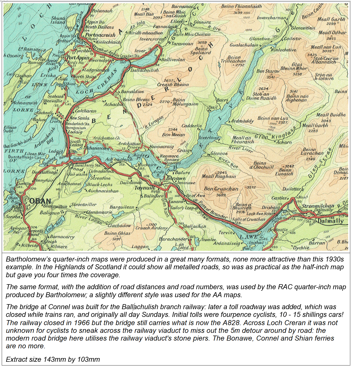
Href6 Line 604
Bartholomew’s Quarter-Inch Maps of England & Wales
Bartholomew’s Quarter-inch England & Wales, 1866 - 1927
Just as Bartholomew had produced a sectional map of Scotland, on the quarter-inch scale for A. & C. Black, in 1866 a similar map of England and Wales was compiled. Like the Scottish map, the individual sheets were segments making up the full map and not optimised for individual convenience. In 1868 the mapping, using the same sheet boundaries, also appeared in the Imperial Map and Atlas, published by Archibald Fullarton & Company. However, unlike the Scotland mapping, an additional series of smaller, cheaper and more practical maps (generally referred to as the ‘Pocket Series’) was derived from this base map, sold by the likes of W. H. Smith. The early history of the Black’s map and that of the Pocket Series is given above. These maps effectively superseded the Black’s originals, which were never strongly promoted, though the sixteen plates for it were regularly updated and formed the master mapping for the local sheets. Ironically, the glowing testimony, long appearing above the index to the Pocket Series maps: ‘These splendid maps, unquestionably the most perfect ever published’, was in fact written in repect of Black’s original map.

In 1890, the maps were rebranded as ‘W. H. Smith’s Tourists’ and Cyclists’ Map of England and Wales from the Ordnance Survey in 16 Sheets’, dropping the Black’s name. In 1893 the sixteen-sheet series was reissued and marketed directly as Bartholomew maps alongside the Smith's editions. Whether for urgency or cheapness the sheet areas were those of the 1866 Black’s maps, which perpetuated the inconvenience of certain sheets (see original index map under A. & C. Black section). Even the sheet border styles reflected that of the 1866 map: the external border, corresponding to that of the full England & Wales wall map, was subdivided into minutes of longitude and latitude, whereas that between adjacent sheets was simpler and there was no overlap between them. Tints were used for county boundaries and main roads were highlighted in brown, as with the ‘Pocket Series’. Covers were red board with a cream-coloured label giving the above title, the particular sheet number and the Bartholomew name. There was, subsequently, also a W. H. Smith ‘cover version’, entitled ‘Cyclist’s Road Map’, in blue. These would duplicate the smaller, but more convenient, Pocket Map series. Prices were 1 shilling on paper, 2 shillings on cloth.
A new index map of the series appeared on the back covers of contemporary half- and quarter-inch maps, or within the indexes pasted inside. The revised mapping was also used in the Royal Atlas of England & Wales, published 1895 by George Newnes. Copies taken from the 1897 edition of the atlas were reprinted as nine huge sheets by Old House Books in 2005, though wrongly termed Ordnance Survey maps.
.jpg)

H. Grube’s Fifty Miles Round London map used the same base mapping. The CTC Handbook for 1923 refers to the Bartholomew series, price 2/6 on cloth, dissected 3/6. The maps were also published as a Touring Atlas & Gazetteer, and in a version for the RAC (dissected on cloth only, 2/6). These RAC maps had major routes emphasised and included distances - an extract is given under the RAC section on the Miscellaneous Publishers page. The sheets also formed a set for the Automobile Association Touring Department, with plain yellow covers.

href6B Line 610
Bartholomew’s 1920s onwards Quarter-inch Gt Britain Maps
The replacement of the old quarter-inch mapping by new was long overdue, but its implementation seems to have been very drawn out. As far back as 1911 a new Scottish series, in seven sheets, had been completed (see above) and in that year the longstanding Environs of London map had been republished using the same new style on a mapping base similarly reduced from the half-inch map.

Finally, entirely new quarter-inch mapping, similar to that produced for Scotland and the London area, was produced for the remainder of England and Wales. I have called this the 1927 mapping, as this seems to be the earliest date of national coverage as ascertained below.

In producing the new maps, a number of minor roads which had been shown on the previous quarter-inch series were omitted. This new mapping was published some years after the introduction of the Ministry of Transport’s “A” and “B” route numbering in 1923, but, rather embarrassingly, some of these classifications were applied to roads left off the new maps. This seems to have arisen through deriving the quarter-inch maps from Bartholomew’s contemporary half-inch maps, and excluding roads given a low (or no) condition ranking. Another throwback was the retention of all passenger railway lines and stations closed since c. 1913 (such as the ‘ghost’ line to Collywell Bay, on the extract below), though alongside the inclusion of the relatively few rail openings up to publication. My conclusion is that a considerable amount of work on the England & Wales maps must have been carried out before the First World War. This makes the 1927 Newnes atlas valuable in two respects: as showing virtually all British railway passenger lines ever to have existed, and as an index to the MoT road numbering scheme more or less as first implemented. In this respect, it still shows the Boroughbridge to Scotch Corner road as part of the A66 (running from Hull and York to Penrith), rather than the A1, with the latter taking the Northallerton route to Darlington and ultimately Edinburgh. Local pressure for the Scotch Corner route to take precedence led to its renumbering to A1 as early as 1924.

What purports to be a reconstruction of a 1900 Bartholomew Road Atlas, on the quarter-inch scale, was published a few years ago. However, the base mapping actually used is that of the 1927 new series, and what is more includes roads not commenced until the 1930s!

This 1927 mapping was used by several publishers for their series of motoring and cycling maps over many years. The most widely-produced of these was the Bartholomew ‘Automobile Map’, produced in conjunction with the AA, which transferred from the old to the new quarter-inch mapping. The series covered Great Britain (excluding the Scottish islands) in 23 sheets, all as first published bearing a January 1929 date, though most did not appear until 1930.
Initially there was what I take to be an AA Members’ cover style, in orange, and with ‘Automobile Association’ taking precedence over the Bartholomew name: no price was indicated but presumably these maps were sold at a discount on the standard price. Alongside these were what was to be the ‘standard’ cover, with the Bartholomew name prominent. The maps themselves were from the same print runs and had a diamond-pattern border. MoT “A” and “B” road numbers were shown, although Bartholomew retained its own quality categorisation by colour which was often at odds with the new numbering. Roads were divided into ‘Main Throughways’ (dark red), ‘Good Motoring Roads’ (red), ‘Other Serviceable Roads’ (yellow), plus an uncoloured category described as ‘roads ‘not in general use’, presumably those considered too venturesome for motorists of the day. An oddity was the insertion of a hyphen with the road number, e.g. A-49, B-2345. The initial contour-colouring was a mix of green for terrain up to 500ft and thence rather heavy browns.
A number of changes were soon made: the map borders marked out in miles, the contour-colouring altered to more lightly-applied shades of brown only, and the hyphens in road numbers dropped. Mapped area width was increased from approximately 685mm to 700mm and height from 385mm to 400mm, giving a map are of about 63 miles by 110. The ‘Main Throughways’ were now shown in normal red but with a series of white dots. The background colour of the covers, originally red, was changed to yellow. All these changes had been made by 1933. The separate orange cover version for AA members was dropped.
The map prices fluctuated. Initial prices seem to have been 1/6d paper, 2s mounted on cloth and 3s dissected (as advertised by Bartholomew, 1930, though other figures have been seen), with reductions for AA members. By 1935 prices for the maps had been reduced to 1/- paper, 2/- mounted on cloth and 2/6 dissected, though a new edition advertised but not apparently implemented that year was to be sixpence higher. WW2 resulted in prices being increased again.
The Automobile maps continued in production until at least the 1950s. All but the wartime revisions are dated directly at the foot of the maps. The same mapping appeared in the AA’s ‘Throughways’ duplex maps of London (1928) and Birmingham (1932), backed by street maps. There was a similar post-war map (1956) of Liverpool, Manchester, Sheffield and Leeds.
By this time all these routes had long been used by sporting motorists (and certainly motorcyclists), so their downgrading suggests a rather cautious approach by the revisers. However, unlike the AA maps, various versions of the quarter-inch map were to appear without the useful dual yellow/uncoloured category distinction for unclassified roads, such as uncoloured map extracts in guidebooks and the RAC maps mentioned below. For these, the omission of borderline-quality roads might have been justified. All of course had regularly been used by pedal cyclists, to whom the omissions were unhelpful. I suppose that their omission at least meant cyclists armed with their half-inch maps could enjoy these useful links with less intrusion from motor traffic than might otherwise have been the case.
The Swaledale routes mentioned above were only reinstated to the maps and atlas much later, along with the upgrading of the Wrynose/ Hardknott route (and Dunnerdale branch) to ‘uncoloured’ road, once wartime damage by military traffic had been repaired. One or two roads were never restored – Mastiles Lane quite rightly disappeared entirely from the map (a 1965 proposal to improve it for motor vehicles was successfully opposed) and the direct road from Ingleton to Dent via Kingsdale was to remain forever a ‘Bridle or footpath’, despite being tarred in 1952. Of course, a great number of minor roads never appeared on the quarter-inch map anyway, but the omission of many potentially-useful links must mark them down as cycling maps. But some significant roads never appearing pre-war were later added; examples include the Rhayader – Devil’s Bridge road, and the road past Ditchling Beacon, the final killer on the London to Brighton Ride. It is interesting to compare the appearance or not of such ‘marginal’ roads on the Bartholomew quarter-inch maps with the equivalent network displayed on the contemporary OS quarter-inch maps, which went through a similar phase of excision.

By publishing maps ‘revised by the Automobile Association’ Bartholomew strengthened its motoring credentials, whilst the AA could use the popularity and reputation of the Bartholomew brand in raising its own profile. As well as this quarter-inch series, Bartholomew’s half-inch maps were also available in an AA cover to its members. There does not seem to have been a series of solely Bartholomew-branded quarter-inch maps for England and Wales ever issued during the life of the Automobile Map series, though the earlier-established Bartholomew-branded maps of Scotland continued in parallel production for a few years. These differed, for a time at least, in not showing MoT road numbers. In 1938 the Automobile Maps were available in double-sided format, dissected on cloth, with one standard sheet each side.

The Newnes' version of the Bartholomew quarter-inch mapping was used for the 1935 News Chronicle Motoring Atlas. It was also used to promote two of Newnes' journals: first as the 1935 Practical Motorist road atlas, then in 1936 as The Cyclist’s Touring Atlas & Gazetteer. This was published by Newnes to coincide with the launch of its weekly paper, The Cyclist. It was largely identical in map sheets to the 1927 Newnes ‘motoring’ atlas, but now with additional coverage of southwest Scotland, and similarly lacked contour colouring. Scale was reduced to five miles to an inch and, like all post 1927 revisions, some minor roads useful to cyclists had been deleted. A gazetteer of town populations was included (Early Closing Days would have been more useful) and a 1938 edition included some cycling-related information of the sort readily available anyway. Too bulky to be taken on the road, it is difficult to see it being of any value outside a cycling club library. The actual publisher’s name was unstated, unless on a long-lost dust cover. An identical volume without the cyclist attribution was sold as Pearson’s Touring Atlas and Gazetteer, Pearson being part of the Newnes group.
The base quarter-inch mapping was not published as a road atlas under Bartholomew's own name until 1944, and probably with limited initial availability. Scale had been reduced to 1:300,000, with contour-colouring. This atlas was republished frequently until c. 1983, by which time all of mainland Scotland was included at the main scale. The AA Road Books of England & Wales and Scotland in the 1960s also used this mapping. The equivalent AA Road Book for Ireland used specially-drawn five miles to the inch Bartholomew’s mapping,
In the 1970s the 1927 mapping was still being used as a base for Bartholomew’s ‘GT’ series of maps, covering Great Britain in ten sheets. The contour-colouring had been dropped and the maps were wholly marketed at motorists. These remained in production into the 1980s, though by that date few cyclists would be using these or similar maps on such scales.
Href7
Bartholomew’s Quarter-Inch Maps of Ireland
NB A map of all Ireland to the scale of 10 miles to an inch had been produced by Bartholomew in 1891. In style it replicated the earlier maps on this scale for England & Wales and Scotland. This is described in an earlier section.
In the late 1890s Bartholomew developed national mapping of Ireland on
the scale of four miles to an inch, 1:253,440. The first of the individual maps
appeared in 1896, the last in 1904 or 1905, the earlier
sheets initially included in the general ‘Pocket Series’ index, before being
subsumed into the national series of seven sheets.
Belfast & NE Counties (published 1900, including city plan of Belfast)
Donegal
County (from 1897)
Killarney
Lake District (from 1896; Killarney & Cork from1897)


Although from 1904 the Irish ¼” maps were advertised as a full contour-coloured national series of quarter-inch maps, it seems that it was 1905 before sheets Connemara & Sligo and Donegal & Enniskillen actually appeared at the new prices and as completing the series. The earliest full key plan included with any of the Touring Maps that I can confidently date is 1906. The new numbering and names:
1 Donegal & Enniskillen 2 Belfast & N. E. Counties 3 Connemara, Mayo (also Connemara & Sligo) |
| 4 Limerick, Galway 5 Cork, Kerry 6 Dublin & Athlone 7 Waterford, Wexford (also Wexford & Waterford) |
1904 also saw the appearance of the Ordnance Survey’s series of maps of Ireland on the quarter-inch scale, based on the revision of the one-inch map of a few years earlier, so providing a direct competitor for Bartholomew. whose maps were reduced from earlier OS editions. Some detail from the new one-inch mapping must have subsequently been incorporated into the Bartholomew maps, but the earlier base mapping was retained until the demise of the series.
The overall style of the final Bartholomew Irish quarter-inch mapping was very similar to the that of the Bartholomew half-inch mapping of Great Britain: cyclists used to the latter had to remember distances on the Irish maps were proportionately greater! Contours were also fewer, at 250, 500, and thence every 500 feet, though on some sheets they were not, initially, fully accurate. The same arrangement for revision by the CTC applied to the Bartholomew quarter-inch maps as to the Great Britain half-inch maps, and similarly CTC members could get a 25% discount on them. Road categorisation went through similar stages of development and later regression. Prices followed those for the Gt Britain half-inch mapsAn AA Members’ version in yellow covers was also produced by the 1920s.
An oddity was that, after the introduction of road numbers in the 1920s, for many years the maps showed those for Northern Ireland but not those within the Republic.
